Question

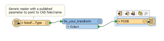
can I make a single model for any CAD file to send it as Esri file geodatabase ? ( transform some lines in CAD to polygons in GIS )


3 replies

fmelizard
Safer
Forum|alt.badge.img+18
  • Safer
  • June 15, 2017

Hi @yasser_nl. Welcome to the FME Knowledge Center! Have you checked out the following demo CAD to GIS: Convert Parcel Lines and Text from DGN to Geodatabase ?


austinh
Contributor
Forum|alt.badge.img+4
  • Contributor
  • June 15, 2017

Use a Generic Reader to read you CAD file and pass the file name and location to the workbench with a Published Parameter. It is easiest if the layers in the expected CAD file are consistent. @yasser_nl


  • Author
  • June 16, 2017
fmelizard wrote:

Hi @yasser_nl. Welcome to the FME Knowledge Center! Have you checked out the following demo CAD to GIS: Convert Parcel Lines and Text from DGN to Geodatabase ?

thank you very much .... this is useful but still suitable only for this project. I try to make one model works with any CAD file .


Cookie policy

We use cookies to enhance and personalize your experience. If you accept you agree to our full cookie policy. Learn more about our cookies.

 
Cookie settings