There are GML/FGDB dataset with "round conner polygon" or multilines geometry which is mixed "curve and lines". It can't be written into GPKG file.
src dataset geometry
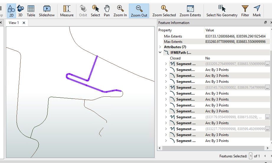
The output geometry is IFMENull
How can fix it?
There are GML/FGDB dataset with "round conner polygon" or multilines geometry which is mixed "curve and lines". It can't be written into GPKG file.
src dataset geometry
The output geometry is IFMENull
How can fix it?
It depends on a few factors, but it should be possible. First make sure to use a generic geometry field on the writer. If you're writing to an existing geopackage with a specific geometry type that excludes arcs, you can insert an ArcStroker just before the writer.
You might also want to try using a GeometryRefiner and possibly also a GeometryValidator (OGC checks) to make sure all geometries are valid.
Thanks, I will try
After GeometryRefiner, we have point, line , polygon, arc, ellipse, surface ...
I use MULTICURVE to map arc, but
What's Geometry type in GPKG can map ellipse?
What's Geometry type in GPKG for surface?
I try to use GeometryValidator (OGC checks), It classify all my MULTICURVE geometries or mixture of MULTILINESTRING and MULTICURVE geometries as failed.
Then how can I fix it
After GeometryRefiner, we have point, line , polygon, arc, ellipse, surface ...
I use MULTICURVE to map arc, but
What's Geometry type in GPKG can map ellipse?
What's Geometry type in GPKG for surface?
Ellipses and surfaces aren't supported in a GeoPackage, see https://docs.safe.com/fme/html/FME_Desktop_Documentation/FME_ReadersWriters/ogcgeopackage/quick_facts_ogcgeopackage.htm
I try to use GeometryValidator (OGC checks), It classify all my MULTICURVE geometries or mixture of MULTILINESTRING and MULTICURVE geometries as failed.
Then how can I fix it
Did you try using a generic geometry column in the GeoPackage table? That should work.
Ellipses and surfaces aren't supported in a GeoPackage, see https://docs.safe.com/fme/html/FME_Desktop_Documentation/FME_ReadersWriters/ogcgeopackage/quick_facts_ogcgeopackage.htm
Thanks
Did you try using a generic geometry column in the GeoPackage table? That should work.
I will try, thanks
Did you try using a generic geometry column in the GeoPackage table? That should work.
I'm so new for FME. How can I set generic geometry column? Thanks
Did you try using a generic geometry column in the GeoPackage table? That should work.
Try this:
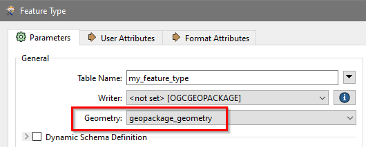
Did you try using a generic geometry column in the GeoPackage table? That should work.
Thanks, I will try
Did you try using a generic geometry column in the GeoPackage table? That should work.
Thanks for your help, this setting solve some of my problems. But Now I got this error when use the setting to convert dataset
...
Our geometry Data is this
what's Non-Cirular Arc.
Is this