I use FME to generate a PostGIS table from a Shape file.
When the value of an attribute type real is set =NULL, FME displays it as =0.
I don't know if the problem is due to :
A bug of FME (misunderstanding of NULL attribute)
A problem of the input Software that generate Empty string value : It should not be possible to generate empty string with numeric attributes?
Thanks
Best answer by ebygomm
ronan wrote:
Yes it seems like it depends on the softwares. For exemple here is the result with the same input using QGIS I don't know why the displying of NULL attribute is different depending on the software used. The problem is I cannot control the API generating the Shapefile.
It's risky to create shapefiles with nulls as is not officially supported and as you have seen are not treated consistently across different software. Chances are a shapefile is going to go near ESRI software (or FME) at some point data is going to be interpreted incorrectly. It looks like some software have added support for nulls as it is technically possible even though not officially supported. I think it's unlikely that null support will be added in FME.
Yes I have tried but the problem is FME reads directly NULL values as = 0. But the value of the attribute=0 can exists also. The NullAttributeMapper cannot know when the input attribute is NULL or =0. I need to know when the value of the attribute =0 or = NULL.
I cannot change the value of the attribute of the Input Shape because the shape file is generated automically from an API using functions I cannot change.
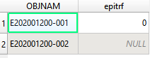
Here is an exemple. You can look at the value of epitrf using QGIS for exemple (1=0, 1 = NULL) and using FME (Both =0).
Yes I have tried but the problem is FME reads directly NULL values as = 0. But the value of the attribute=0 can exists also. The NullAttributeMapper cannot know when the input attribute is NULL or =0. I need to know when the value of the attribute =0 or = NULL.
I cannot change the value of the attribute of the Input Shape because the shape file is generated automically from an API using functions I cannot change.
Here is an exemple. You can look at the value of epitrf using QGIS for exemple (1=0, 1 = NULL) and using FME (Both =0).
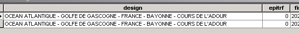
If I open that file in ArcMap, epitrf is displayed as zero for both records, and querying epitrf is null returns no records, FME replicates this.
I can see as you do in QGIS that one is null and one is zero.
Shapefiles cannot actually support null values, so i think this is QGIS doing something differently.
Yes it seems like it depends on the softwares. For exemple here is the result with the same input using QGIS I don't know why the displying of NULL attribute is different depending on the software used. The problem is I cannot control the API generating the Shapefile.
Yes it seems like it depends on the softwares. For exemple here is the result with the same input using QGIS I don't know why the displying of NULL attribute is different depending on the software used. The problem is I cannot control the API generating the Shapefile.
It's risky to create shapefiles with nulls as is not officially supported and as you have seen are not treated consistently across different software. Chances are a shapefile is going to go near ESRI software (or FME) at some point data is going to be interpreted incorrectly. It looks like some software have added support for nulls as it is technically possible even though not officially supported. I think it's unlikely that null support will be added in FME.
Thanks a lot. Your answer is what I feared : The problem is due to a lack of interpretation of other softwares. A least, I know why, and yes, it is logical that FME won't be updated to adapt to a problem caused by other softwares... Thanks a lot
Thanks a lot. Your answer is what I feared : The problem is due to a lack of interpretation of other softwares. A least, I know why, and yes, it is logical that FME won't be updated to adapt to a problem caused by other softwares... Thanks a lot
I don't know whether it may be possible to read the shapefiles with python and get the distinction between not set and zero for the empty attributes, it's not something I've ever had cause to explore.
We use 3 different kinds of cookies. You can choose which cookies you want to accept. We need basic cookies to make this site work, therefore these are the minimum you can select. Learn more about our cookies.


 I don't know why the displying of NULL attribute is different depending on the software used. The problem is I cannot control the API generating the Shapefile.


 I can see as you do in QGIS that one is null and one is zero.