Hi all,

I am just wondering if someone can assist or provide pointers on how to generate a navigation tree in FME writing to a GeoJSON file, to be opened in arcGIS pro. My input/reader file is a CSV. For example, in the arcGIS navigation tree, data of types of poles should present as follows:


Pole

-> Steel

->->Blue

->->-> Pole A

->->-> Pole B

->->-> Pole C

-> Plastics

->-> Blue

->->-> Pole D

->-> Red

->->-> Pole E

Hey there!


Would be great if you could provide a sample json with how the data is structured.

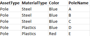
Also, what would you want to do with the end result? Your current structure looks like poles are part of a material type and then color group per material type. You could also use FME to restructure your data and make it more feature-based with attributes assigned to those features, instead of the parent/child relation determining what the attributes of a pole are, so that would result in something like this;

imageWith this setup, you'll be able to assign symbology and other layer configurations in ArcGIS pro based on these attributes.


Creating this table can of course be done in FME, using the (geo)json you have as a source. If you can provide the json structure, I'm sure we can help you out!


Hope this helps!


Regards,


Pim

Hey Pim,

Thank you very much for your response. My apologies for confusion, my input data source is a CSV which needs to turn into geoJSON (or any file that can show hierarchial structure on ArcGIS Pro). Your sample table looks exactly how my CSV does currently. My workbench currently outputs to a geoJSON and plots my data in arcGIS. Now I am hoping to build a navigation tree from

material->colour->pole ID

To easily navigate the data (as it is very large) and so you can view specific materials and/or colours.


This is a simplified example of what I want to do. But if I understand how to do it and the basics with a simple set, it should be easier. Eventually the navigation tree will organise the data and a heatmap will also display with the points in arcGIS.


Hey there!


Would be great if you could provide a sample json with how the data is structured.

Also, what would you want to do with the end result? Your current structure looks like poles are part of a material type and then color group per material type. You could also use FME to restructure your data and make it more feature-based with attributes assigned to those features, instead of the parent/child relation determining what the attributes of a pole are, so that would result in something like this;

imageWith this setup, you'll be able to assign symbology and other layer configurations in ArcGIS pro based on these attributes.


Creating this table can of course be done in FME, using the (geo)json you have as a source. If you can provide the json structure, I'm sure we can help you out!


Hope this helps!


Regards,


Pim

Also, as you mentioned, do you know how to add symbology layers in FME to display in arcGIS? I wish to set the symbology of my data points to a heat map. I can't find a way to do it within FME using transformers.


Reply