Question

TIFF/GRD Raster Data into a csv/table

  • December 17, 2024
  • 4 replies
  • 115 views

aniqak
Contributor
Forum|alt.badge.img+1

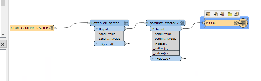
Hi, I am trying to convert raster data in the forms of .grd, tiff or GRID from ArcGIS Pro into a csv/table. If anyone can point me in the right direction, that would be greatly appreciated. 


GRD file loaded on ArcGIS Pro


4 replies

philipwhitten
Supporter
Forum|alt.badge.img+15
  • Supporter
  • December 18, 2024

Could you add a few details about what type of structure that you want in your csv file or table?  For example, are you wanting something like:

  • coordinates with raster values

x_vlaue, y_value, raster_band_1_value

1,1,6

2,1,7

3,1,8

x_value y_value raster_band_1_value
1 1 6
2 1 7
3 1 8


  • (e.g. row 1: x value, y value, raster band 1, raster band 2 value)

6,7,8

5,4,3

2,7,4

  1st_column 2nd_column 3rd_column
1st_row 6 7 8
2nd_row 5 4 3
3rd_row 2 7 4
  • Or something entirely different like a summary?

aniqak
Contributor
Forum|alt.badge.img+1
  • Author
  • Contributor
  • December 18, 2024

Yes, something like coordinates with the raster band value. 


aniqak
Contributor
Forum|alt.badge.img+1
  • Author
  • Contributor
  • December 18, 2024
Current Workflow
Output

I would like to remove the A column entries that are e+## and have more specific coordinates


philipwhitten
Supporter
Forum|alt.badge.img+15
  • Supporter
  • December 20, 2024

Is column A band value (_band{}.value)?  If column A is a band value, then the entries that are E+## are possibly the NoData values.  If they are NoData values then you could set the Parameter for “Extract Nodata” in the RasterCellCoercer to “No”.  You also might have to set the NoData value using the RasterBandNodataSetter.


The coordinates are dependent on what projection you are using.  You could consider reprojecting if you would like more specific coordinates.