I am creating a Spatialite database with FME
2016.1 64 bit. I have both polygons and lines. Polygons shows up perfectly, but
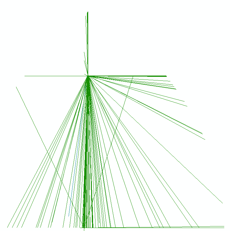
the lines are all over the place. I have added a picture showing the lines that
should have depicted a road network in a municipality. Have anyone had the same
experience or any idea why the lines drawn like this? I have been trying to adjust
how ArcMap reads the data with the "query dialogue" but no success. My ArcGIS version
is 10.3.1
Hi @geogaard, if you read the SpatiaLite data with FME Data Inspector, how is it displayed?


Hi @geogaard, if you read the SpatiaLite data with FME Data Inspector, how is it displayed?

Hi @takashi here is the view in inspector. This is also what I would expect ArcMap to show.


You say polygons come across just fine, so I'm assuming it's not a projection issue. Are you doing any kind of processing in between or just doing a simple a-to-b conversion?


Hi @takashi here is the view in inspector. This is also what I would expect ArcMap to show.

OK. I was able to reproduce similar symptom to yours. It seems that ArcMap does not display 3D SpatiaLite lines from FME correctly. I don't know which is wrong, ArcMap or FME.
As a meantime workaround, try writing the data in 2D. You can use the 2DForcer transformer to change 3D to 2D.


You say polygons come across just fine, so I'm assuming it's not a projection issue. Are you doing any kind of processing in between or just doing a simple a-to-b conversion?

It's just a simple a-to-b conversion. Not doing anything different with the lines contra the polygons.


OK. I was able to reproduce similar symptom to yours. It seems that ArcMap does not display 3D SpatiaLite lines from FME correctly. I don't know which is wrong, ArcMap or FME.
As a meantime workaround, try writing the data in 2D. You can use the 2DForcer transformer to change 3D to 2D.

Thank you. You are right, there seems to be a problem with 3D data. Once in 2D it works as expected.


Thank you. You are right, there seems to be a problem with 3D data. Once in 2D it works as expected.

I'm wondering if the unexpected shapes caused by a bug in FME. Hope someone from Safe will investigate this.


Thank you. You are right, there seems to be a problem with 3D data. Once in 2D it works as expected.

I've looked and I don't find any previous reports of this problem. Can @geogaard can you submit a case to our support team to report the problem? See http://www.safe.com/support - please include the version of FME and ArcGIS you are using. Thanks


Thank you. You are right, there seems to be a problem with 3D data. Once in 2D it works as expected.

Hi @Mark2AtSafe, I also reported my reproduction to your support team - C113837. Regards.


Hi @Mark2AtSafe, I also reported my reproduction to your support team - C113837. Regards.

Thanks Takashi. I warned the developers that there was a problem coming their way, so hopefully they will have a head start on fixing it.


Thanks a lot, @HeatherS and @geogaard 

This is EXACTLY what I need to write cross-plattform spatiaLite. Just change these default FME options: 

DONT use generic geometry (you have  to choose geometrytype explisit, in my case wkb_line_xyz). 

DONT compress geometry column. 

I haven't checked this thoroughly, but now it seems to work fine in both QGIS and arc map. 

QGIS does spew out some non-helpful complaints in the log, though: 

query fails: SELECT styleQML FROM layer_styles WHERE f_table_catalog=<my sqlite file> 
AND table_schema='' 
AND f_table_name=<my table> 
AND f_geometry_column='GEOMETRY' 
ORDER BY CASE WHEN useAsDefault THEN 1 ELSE 2 END,update_time DESC LIMIT 1

Reply