Using FME Server build 18305
I am testing the Upload multiple files in the FME Server REST API V3 on my server.
The goal is to upload a shape file using the POST /resources/connections/< resource >/filesys/< path > (Upload multiple files) method but getting stuck on using the file due to corruption.
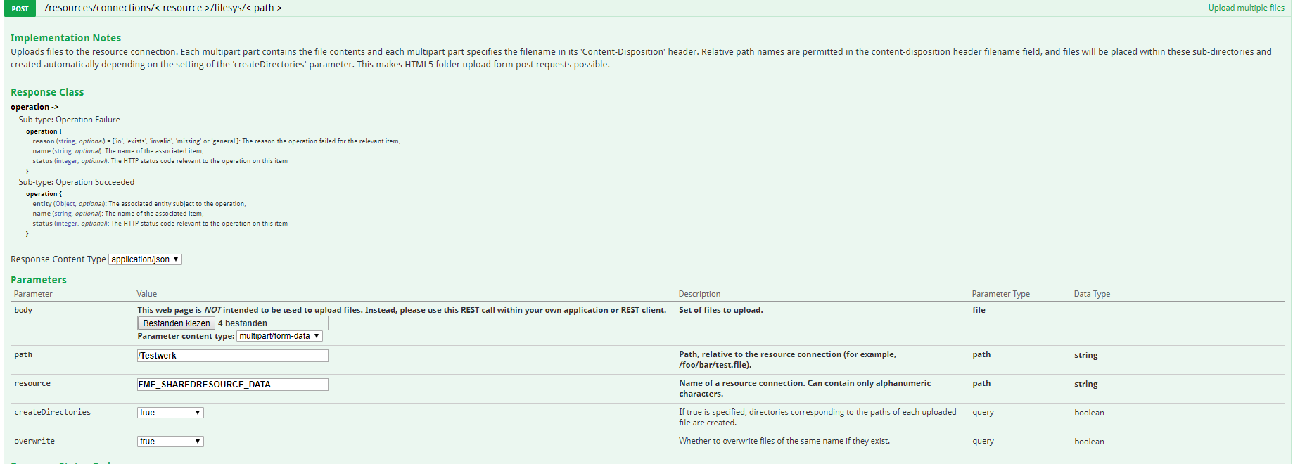
These are the settings:

The return looks like this:
Response Code:
200
Response Body
[
  {
    "date": "2018-10-22T11:09:43Z",
    "path": "/Testwerk/",
    "size": 8360,
    "name": "waterschapsgrenzen.dbf",
    "type": "FILE"
  },
  {
    "date": "2018-10-22T11:09:43Z",
    "path": "/Testwerk/",
    "size": 428,
    "name": "waterschapsgrenzen.prj",
    "type": "FILE"
  },
  {
    "date": "2018-10-22T11:09:43Z",
    "path": "/Testwerk/",
    "size": 170,
    "name": "waterschapsgrenzen.shx",
    "type": "FILE"
  },
  {
    "date": "2018-10-22T11:09:43Z",
    "path": "/Testwerk/",
    "size": 960243,
    "name": "waterschapsgrenzen.shp",
    "type": "FILE"
  }
]
Everything looks OK till now, but when downloading and inspecting the shapes with the Data Inspector or useing it in flow the following error with the dbf pops up:
Log File: C:\Users\jeroen\AppData\Local\Temp\FMEDataInspector\logs\fmedatainspector_2018-10-22T13-21-08.log

Loaded module 'fmeprompter' from file 'fmeprompter.dll'

'ESRISHAPE' reader was created successfully

Creating reader for format: Esri Shapefile

The dataset 'C:\Users\jeroen\Downloads\waterschapsgrenzen.shp' was opened successfully

The feature cache has not been loaded while a new setConstraints was performed. Now loading...

Using Shape Reader to read shape files from folder `C:\Users\jeroen\Downloads/'

R_1 Reader: Using enhanced geometry

Shape Reader: Using simple donut geometry detection

Shape Reader: Handling numeric types with standard integer and floating point types

Shape Reader: Allowing attribute names with mixed case

Opened Shape File 'C:\Users\jeroen\Downloads\waterschapsgrenzen.shp' for input

Opened DBF File 'C:\Users\jeroen\Downloads\waterschapsgrenzen.dbf' for input

DBF Reader: Could not detect encoding. Using default system encoding

DBF File 'C:\Users\jeroen\Downloads\waterschapsgrenzen.dbf' has fields: A DBF Internal Type Designation '

The OGC definition of the FME coordinate system '_Netherlands-RDNew-2008_0' is 'PROJCS["RD_New",GEOGCS["GCS_Amersfoort",DATUM["D_Amersfoort",SPHEROID["Bessel_1841",6377397.155,299.1528128]],PRIMEM["Greenwich",0.0],UNIT["Degree",0.0174532925199433]],PROJECTION["Double_Stereographic"],PARAMETER["False_Easting",155000.0],PARAMETER["False_Northing",463000.0],PARAMETER["Central_Meridian",5.38763888888889],PARAMETER["Scale_Factor",0.9999079],PARAMETER["Latitude_Of_Origin",52.15616055555555],UNIT["Meter",1.0]]'

FME Configuration: Source coordinate system for reader R_1[ESRISHAPE] set to `_Netherlands-RDNew-2008_0' as read from input data

Coordinate System `_Netherlands-RDNew-2008_0' parameters: CS_NAME=`_Netherlands-RDNew-2008_0' DESC_NM=`Netherlands, Amersfoort RD 2008 datum, New System' DT_NAME=`Amersfoort-RD-2008' ESRI_WKT=`PROJCS["RD_New",GEOGCS["GCS_Amersfoort",DATUM["D_Amersfoort",SPHEROID["Bessel_1841",6377397.155,299.1528128]],PRIMEM["Greenwich",0.0],UNIT["Degree",0.0174532925199433]],PROJECTION["Double_Stereographic"],PARAMETER["False_Easting",155000.0],PARAMETER["False_Northing",463000.0],PARAMETER["Central_Meridian",5.38763888888889],PARAMETER["Scale_Factor",0.9999079],PARAMETER["Latitude_Of_Origin",52.15616055555555],UNIT["Meter",1.0]]' GROUP=`EUROPE' MAP_SCL=`1' ORG_LAT=`52.15616055555556' ORG_LNG=`5.387638888888889' PROJ=`OSTERO' QUAD=`1' SCL_RED=`0.9999079' SOURCE=`Kadaster' UNIT=`METER' X_OFF=`155000' Y_OFF=`463000'

No shape record found when reading record number '1'.  Shape file is either corrupt or end of file has reached with no meaningful data

Unable to input data from file 'C:\Users\jeroen\Downloads\waterschapsgrenzen.dbf'

Failed to specify the feature index as constraints on the reader

The feature cache has not been loaded while a new setConstraints was performed. Now loading...

No shape record found when reading record number '2'.  Shape file is either corrupt or end of file has reached with no meaningful data

Unable to input data from file 'C:\Users\jeroen\Downloads\waterschapsgrenzen.dbf'

Removing dataset 'waterschapsgrenzen [ESRISHAPE]' from View 1

The dataset 'C:\Users\jeroen\Downloads\waterschapsgrenzen.shp' was closed successfully

The 'ESRISHAPE' reader was destroyed successfully
Is there a way to fix this?
I also saw that the .dbf file has a file size of 8.36KB when uploaded by REST and 8.34KB when i upload it myself using the upload functionality in the Resources folder. Also the other files are larger after uploading.


