Ok, I've a gpx file that I see in the data inspector, I have a mapbox map in the background that I can see too. I want to save this out to a jpeg but it doesn't create any file so I tried saving dataset as a pdf. That works, except it only exports the gpx data, it doesn't include the background map. Is there a way to do this?

Solved
data inspector - map not exporting
Best answer by courtney_m
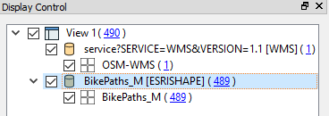
You can do this in Data Inspector if you add the background map as a dataset (rather than as a background map)... For example, if I have a WMS background map (using a WMS reader), and I add it to inspector with a shapefile - in the same view - I can then save the data together as a PDF.
This post is closed to further activity.
It may be an old question, an answered question, an implemented idea, or a notification-only post.
Please check post dates before relying on any information in a question or answer.
For follow-up or related questions, please post a new question or idea.
If there is a genuine update to be made, please contact us and request that the post is reopened.


Login to the community
No account yet? Create an account
An FME Account is required to contribute
LoginEnter your E-mail address. We'll send you an e-mail with instructions to reset your password.