")

Hi all,
I am very much an FME rookie, so I’m hoping someone may have some insight as I’m at a loss.
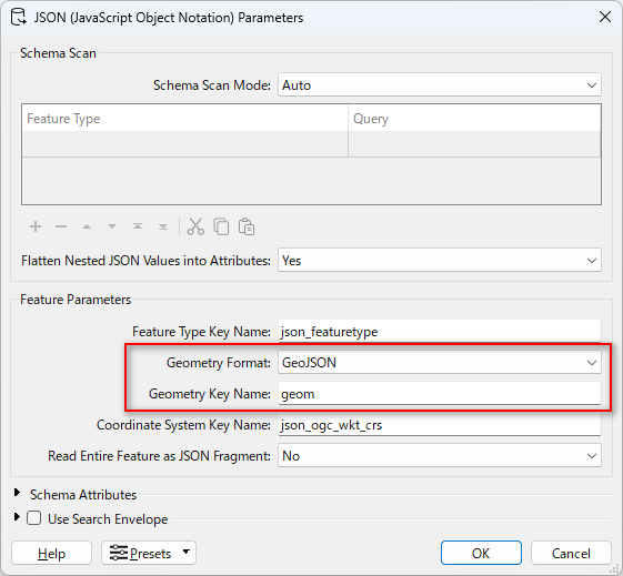
I’ve received a .JSON dataset of point locations with a number of attributes. It is not in a form of GeoJSON that I recognize, and so basic Esri/GIS toolsets won’t help with conversion. I’d like to use FME Form Workbench to help me clean up the data and ultimately convert it to Shapefile or Esri File Geodatabase Feature Class.
Below is the format of the .json that I’m working with:
[

  {

    "id": 1,

    "address_number": "1234",

    "street_name": "IMAGINARY",

    "street_type": "WAY",

    "unit_number": "",

    "country": "CAN",

    "province": "BC",

    "region": "CVRD",

    "locality": "Mill Bay",

    "postal_code": "V8H 1B8",

    "pid": "",

    "administration": "",

    "building_name": null,

    "code": "Residential",

    "comments": null,

    "geom": {

      "type": "Point",

      "coordinates": [

        -123,

        48.6

      ]

    },

    "created_at": "2024-03-27T17:00:00-07:00",

    "updated_at": "2025-04-15T11:47:55.371078-07:00",

    "full_address": "1234 Imaginary Way"

  },
So since it’s “kind of” formatted like a GeoJSON, but not exactly I can convert it to shapefile but the coordinate/spatial data doesn’t come across.
I’ve been trying to extract the coordinate info using translators like JSONFragmenter, JSONFormatter, JSONExtractor etc but I’m clearly not doing something right. I’m hoping someone can steer me in the right direction.
For reference, I’m using version 2024.2 of the software.
Thanks!
Chris