Question

Broken lines that need to be joined and only have start and end point data as attributes

  • September 12, 2017
  • 11 replies
  • 27 views

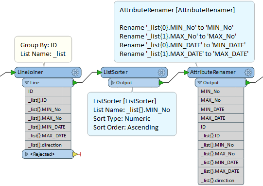
I have Shapefile lines with start and end point data attributed to them, but some of the lines got broken resulting in two lines that should be connected with start and end point data attributed for each section. I am using the Snapper and LineJoiner to connect the lines, but I am not sure how to get the correct end and start times for the full line.

This post is closed to further activity.
It may be an old question, an answered question, an implemented idea, or a notification-only post.
Please check post dates before relying on any information in a question or answer.
For follow-up or related questions, please post a new question or idea.
If there is a genuine update to be made, please contact us and request that the post is reopened.

11 replies

david_r
Celebrity
  • September 12, 2017

Could you maybe post a small sample dataset?


fmelizard
Safer
Forum|alt.badge.img+21
  • Safer
  • September 12, 2017
Hi @pebble, is there an attribute that is common to the segments of the broken line? How do you know which segment belongs with which segment?

  • Author
  • September 13, 2017
Hi @pebble, is there an attribute that is common to the segments of the broken line? How do you know which segment belongs with which segment?
Most of the split lines have a common ID number, but a few have different ID numbers.


  • Author
  • September 13, 2017

Could you maybe post a small sample dataset?

Not sure how to post a shapefile sample? Any help?


mygis
Supporter
Forum|alt.badge.img+14
  • Supporter
  • September 14, 2017
could you please provide us with a screenshot showing the lines?


mygis
Supporter
Forum|alt.badge.img+14
  • Supporter
  • September 14, 2017
Not sure how to post a shapefile sample? Any help?


just compress the files into a single zip file and upload it.


  • Author
  • September 14, 2017
sample.png


mygis
Supporter
Forum|alt.badge.img+14
  • Supporter
  • September 14, 2017
sample.png


Thanks, please post a screeshot of the lines as well.


  • Author
  • September 14, 2017
Thanks, please post a screeshot of the lines as well.


The lines are above the table in the png file.


gio
Contributor
Forum|alt.badge.img+15
  • Contributor
  • September 14, 2017

Sort by ID (as you did )

Listbuilder grouped by ID.

ListRangeExtractor on Min and max time. (2 ListRangeExtractors).

Take care to rename the default values for the relevant Resulting Minimum/Maximum Attribute.


takashi
Celebrity
  • September 14, 2017

Hi @pebble, if the numerical order of MIN_No and MAX_No is synchronized with the temporal order of MIN_DATE and MAX_DATE, this would also be a possible way.

  1. LineJoiner (called LineCombiner in FME 2017+): Set List Name, e.g. "_list".
  2. ListSorter: Sort the list by MIN_No numeric ascending.
  3. AttributeRenamer: Rename _list{0}.MIN_No to MIN_No, _list{1}.MAX_No to MAX_No, _list{0}.MIN_DATE to MIN_DATE, and _list{1}.MAX_DATE to MAX_DATE.