Question

Result differences: SpatialRelator (Within) & Esri-ArcMap: Select by location (Within)

  • February 27, 2019
  • 7 replies
  • 83 views

mz
Contributor
Forum|alt.badge.img+1
  • Contributor

Hello,


I have a difference in my results and I was wondering if this is a ‘known issue’ and how to resolve it.

Goal: Give all the line-objects a “No” when there outside the polygon and a “Yes” when there inside a polygon.


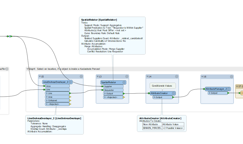
  • FME: I used a SpatialRelator (with the Spatial test: Requestor is Within Supplier option) followed by an Attribute creator which defines the Yes & No.
  • ArcGIS: To check the result I did the same within ArcMap using: Select by location with Within as the selection method.
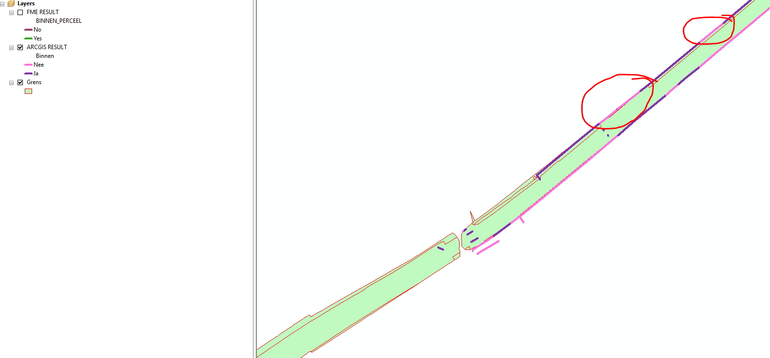
 

Result ArcMap:


Result FME:


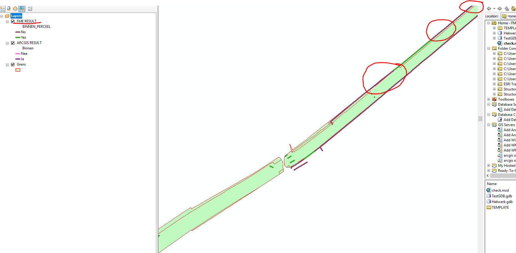
I do understand that we are comparing apples with oranges, but I got some significant differences as you can see above, were from my point of view: Esri-Map is correct.

Since I want to use my FME model, more often, is there a way to solve this problem? Or something I as a start-FME-user forgot to add in my model?
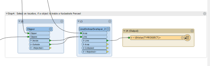
 

Current model:

The used Conditional Values:


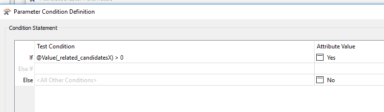
Thanks in advanced for the responses!


7 replies

ebygomm
Influencer
Forum|alt.badge.img+38
  • Influencer
  • February 27, 2019

I suspect that the Arc result is using a tolerance and the FME result is not. It may be worth investigating whether you can get the output you want using the clipper since that will allow you to use a tolerance whereas the spatial relator does not at present. So anything coming out the inside port of the clipper that is not clipped is within the area.


mz
Contributor
Forum|alt.badge.img+1
  • Author
  • Contributor
  • February 28, 2019

First of all, thank you for your reply @egomm.

I tried to experiment with your suggestion, and probably because of the lack of knowledge on this point it did not quite work out. Is it possible to give an concrete example?

In the meantime I used a combination of your suggestion, with the last steps in ArcGIS-Modelbuilder (I needed a result on short notice). Is there a way (transformer) which can start this model in Arcmap or maybe the python alternative within FME?


So this is the current model:


Forum|alt.badge.img+6

Hi @mz!


We think we may know what is happening here: It looks like the SpatialRelator is stroking arcs to lines, which is producing the different result from ArcGIS. There are two pieces of good news, however!


1) If you use the PointOnAreaOverlayer as a substitute for the SpatialRelator, this transformer supports arcs and should produce a more satisfactory result.


2) We have already noted down to tackle arc support in the SpatialRelator, so it is on our radar for future development.


Please give the PointOnAreaOverlayer a shot, and let us know how it goes!


Best,


Annabelle

mz
Contributor
Forum|alt.badge.img+1
  • Author
  • Contributor
  • March 22, 2019
annabelleatsafe wrote:

Hi @mz!


We think we may know what is happening here: It looks like the SpatialRelator is stroking arcs to lines, which is producing the different result from ArcGIS. There are two pieces of good news, however!


1) If you use the PointOnAreaOverlayer as a substitute for the SpatialRelator, this transformer supports arcs and should produce a more satisfactory result.


2) We have already noted down to tackle arc support in the SpatialRelator, so it is on our radar for future development.


Please give the PointOnAreaOverlayer a shot, and let us know how it goes!


Best,


Annabelle

@annabelleatsafe, thank you for your response.

I tried the LineOnAreaOverlayer (sorry it was a line file, instead of an point) on default values and unfortunately that did not make the difference (sorry I do not have any pictures).

Since I was running out of time my solution was to break the script in two parts. I used a Esri-modelbuilder script with a 'select on location & calculate field' as an alternative for this problem.

Good to hear this is a known problem and in development! Please keep me informed (if this is possible of course! :) )


gisbradokla
Enthusiast
Forum|alt.badge.img+17
  • Enthusiast
  • October 25, 2022
mz wrote:

@annabelleatsafe, thank you for your response.

I tried the LineOnAreaOverlayer (sorry it was a line file, instead of an point) on default values and unfortunately that did not make the difference (sorry I do not have any pictures).

Since I was running out of time my solution was to break the script in two parts. I used a Esri-modelbuilder script with a 'select on location & calculate field' as an alternative for this problem.

Good to hear this is a known problem and in development! Please keep me informed (if this is possible of course! :) )

Still have this problem

in 2022


gistech_
Contributor
Forum|alt.badge.img+4
  • Contributor
  • April 7, 2024

Hello,


Running 2023.2 and still face this issue.

is there any open ticket about this issue where I can add my vote? 


Anatoli


nampreetatsafe
Safer
Forum|alt.badge.img+13

Hi @gistech_ .  I found an existing ticket related to this issue (internal reference FMEENGINE-63764).  I’ve referenced this thread in the ticket.


Cookie policy

We use cookies to enhance and personalize your experience. If you accept you agree to our full cookie policy. Learn more about our cookies.

 
Cookie settings