Question

Why is the geotiff reader not picking up the location?


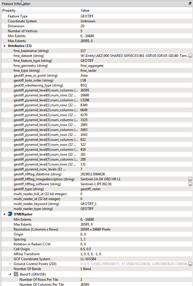
I have a geotiff (sentinel-1 SAR) that i can view correctly in ArcGIS. It shows in ArcGIS properties as being GCS_WGS_1984. If I read it in FME and write to another tiff it is also fine. But within FME it seems to lose the geographic contect and switches to Coordinate system: unknown and in the inspector displays as if the pixel values are geographic coordinates. This means that I cannot perform any geographic operations on it (I plan to use rasterextentcoecer and mapnik).


Is this an issue with my reader, or can I reintroduce the location? The tiff has no world file so I dont actually understand where the georeferencing is stored - but arcgis can read it.

10 replies

redgeographics
Celebrity
Forum|alt.badge.img+49

If it's a GeoTiff the georeferencing is stored in the file's header. FME should be able to read that, what do you see if you use a GeoTiff reader and then direct it to an Inspector?


  • Author
  • January 18, 2019
redgeographics wrote:

If it's a GeoTiff the georeferencing is stored in the file's header. FME should be able to read that, what do you see if you use a GeoTiff reader and then direct it to an Inspector?

In inspector it displays but from 0,0 in the top left corner and the map displays with unknown coordinate system and unknown units. This matches the properties at the top but down in the IFMERaster bit it seems to have the coordinate system and control points but is just ignoring it


redgeographics
Celebrity
Forum|alt.badge.img+49
whatahitson wrote:

In inspector it displays but from 0,0 in the top left corner and the map displays with unknown coordinate system and unknown units. This matches the properties at the top but down in the IFMERaster bit it seems to have the coordinate system and control points but is just ignoring it

If you send it to an Inspector and have a background map showing in the Data Inspector, does the GeoTiff show up in the right location?


  • Author
  • January 18, 2019
redgeographics wrote:

If you send it to an Inspector and have a background map showing in the Data Inspector, does the GeoTiff show up in the right location?

the background map doesn't appear to be loading at the moment but previously no its huge and anchored to null island extending south and east


redgeographics
Celebrity
Forum|alt.badge.img+49
whatahitson wrote:

the background map doesn't appear to be loading at the moment but previously no its huge and anchored to null island extending south and east

That definitely sounds as something wrong with the georeferencing or coordinate system (and something that shouldn't really happen within FME). You can try adding a CoordinateSystemSetter to your workspace to specifically set the coordinate system to LL84


mperry
Contributor
Forum|alt.badge.img+6
  • Contributor
  • February 25, 2019

Hi there,

Also having the same issue here. Geotiffs are loading in ArcMap properly but not in FME. If you use the CoordinateSystemSetter it will force the image to the coordinate system but the origin will still be 0,0.


redgeographics
Celebrity
Forum|alt.badge.img+49
boostpad wrote:

Hi there,

Also having the same issue here. Geotiffs are loading in ArcMap properly but not in FME. If you use the CoordinateSystemSetter it will force the image to the coordinate system but the origin will still be 0,0.


Can you share (a small version of) one of those tiff's here?


mperry
Contributor
Forum|alt.badge.img+6
  • Contributor
  • April 7, 2019
redgeographics wrote:

Can you share (a small version of) one of those tiff's here?

Hi, please find here:


Extract_tif3.tif


rahulsharma
Safer
Forum|alt.badge.img+10
boostpad wrote:

Hi, please find here:


Extract_tif3.tif

@michael.perry5, FME rely on Geotiff world files or the information in the header to get coordinates.


*.tif.aux.xml are auxiliary files that ArcGIS uses to read coordinate system, Currently we do not suppor this but will be adding support for future releases (http://desktop.arcgis.com/en/arcmap/10.6/manage-data/raster-and-images/auxiliary-files.htm )

Can you make a copy of your existing world file and rename the extension to *.tfw and try again using FME?

We only guess the world file extension that has w at the end so anything with *.tifw or *.tifw or *.tiffw or *.wld

Forcing the coordinate system will not work and it needs the GCPs(ground control point) which should be stored in the world file.


mperry
Contributor
Forum|alt.badge.img+6
  • Contributor
  • April 29, 2019
rahulsharma wrote:

@michael.perry5, FME rely on Geotiff world files or the information in the header to get coordinates.


*.tif.aux.xml are auxiliary files that ArcGIS uses to read coordinate system, Currently we do not suppor this but will be adding support for future releases (http://desktop.arcgis.com/en/arcmap/10.6/manage-data/raster-and-images/auxiliary-files.htm )

Can you make a copy of your existing world file and rename the extension to *.tfw and try again using FME?

We only guess the world file extension that has w at the end so anything with *.tifw or *.tifw or *.tiffw or *.wld

Forcing the coordinate system will not work and it needs the GCPs(ground control point) which should be stored in the world file.


Hi rahulsharma, thanks very much for your reply. Very helpful.


Regards


Cookie policy

We use cookies to enhance and personalize your experience. If you accept you agree to our full cookie policy. Learn more about our cookies.

 
Cookie settings