Question

Why does the SurfaceDraper require break lines? And how do I work around it?


aron
Supporter
Forum|alt.badge.img+16
  • Supporter

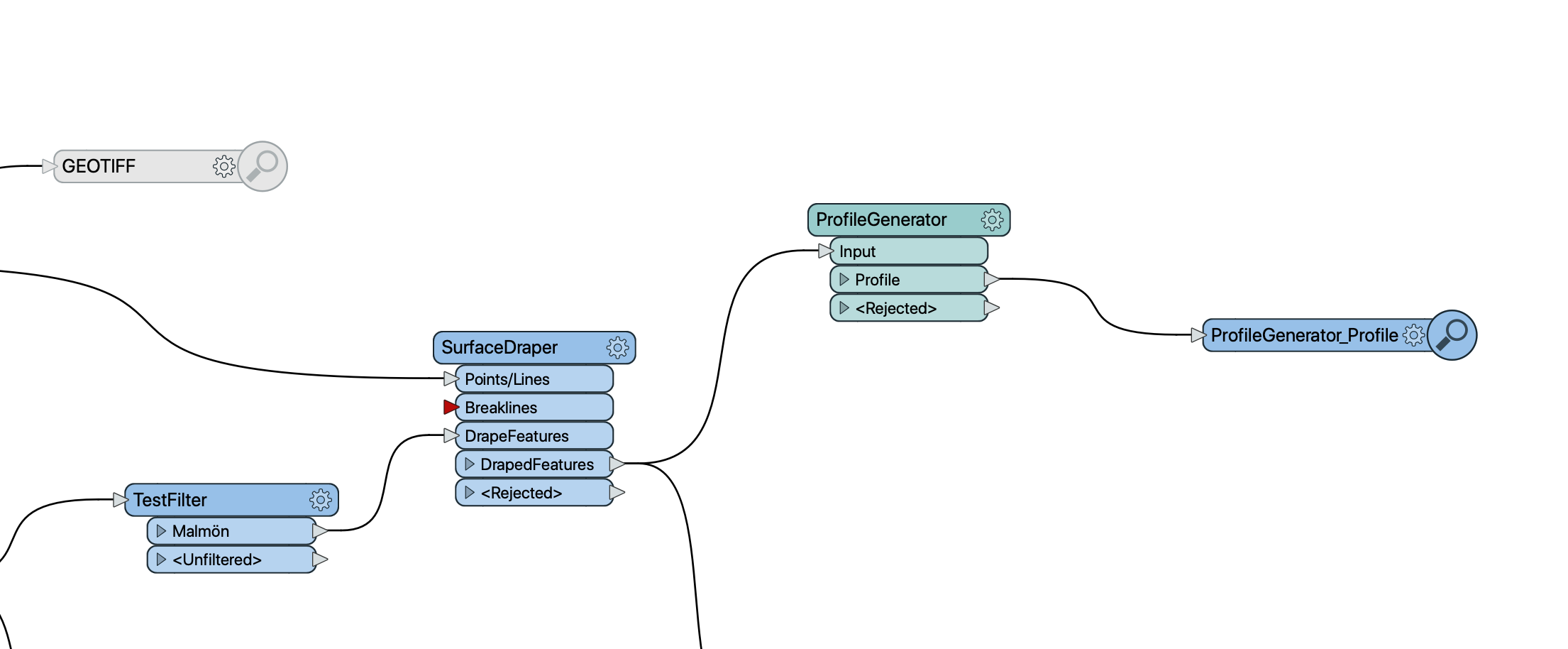
I am trying to use the SurfaceDraper for a project but it wont do anything. The input arrow for Breaklines is red so I that seems to be the culprit. I cant see why breaklines should be mandatory? A polyline and a DEM raster should be enough to do the draping? Is there a workaround for this?


4 replies

erik_jan
Contributor
Forum|alt.badge.img+18
  • Contributor
  • May 27, 2020

I do not believe both Point/Lines and Breaklines are required.

A common issue occurs with Coordinate Systems.

Are the Point/Lines and the DrapeFeatures in the same coordinate system?


aron
Supporter
Forum|alt.badge.img+16
  • Author
  • Supporter
  • May 27, 2020
erik_jan wrote:

I do not believe both Point/Lines and Breaklines are required.

A common issue occurs with Coordinate Systems.

Are the Point/Lines and the DrapeFeatures in the same coordinate system?

I went back and changed both sources into the same coordinate system. Unfortunately that did not do the trick. The sources are one geotiff and one shape file.

redgeographics
Celebrity
Forum|alt.badge.img+49
aron wrote:
I went back and changed both sources into the same coordinate system. Unfortunately that did not do the trick. The sources are one geotiff and one shape file.

As @erik_jan says, you don't need to supply both points/lines and breaklines.

However, I think the SurfaceDraper can't work with a raster DEM, try turning it into 3d points first with a RasterCellCoercer.


aron
Supporter
Forum|alt.badge.img+16
  • Author
  • Supporter
  • May 28, 2020
redgeographics wrote:

As @erik_jan says, you don't need to supply both points/lines and breaklines.

However, I think the SurfaceDraper can't work with a raster DEM, try turning it into 3d points first with a RasterCellCoercer.

Thanks @redgeographics!

I went back and read the documentation for SurfaceDraper and the wording is a bit unclear. The input arrow is called Points/Lines, but in the description it says : "These input features may be 2D or 3D. Other than points, lines and area geometries, they may also be raster, point cloud, and aggregate geometries." Maybe someone at Safe could shine a light at this?


Cookie policy

We use cookies to enhance and personalize your experience. If you accept you agree to our full cookie policy. Learn more about our cookies.

 
Cookie settings