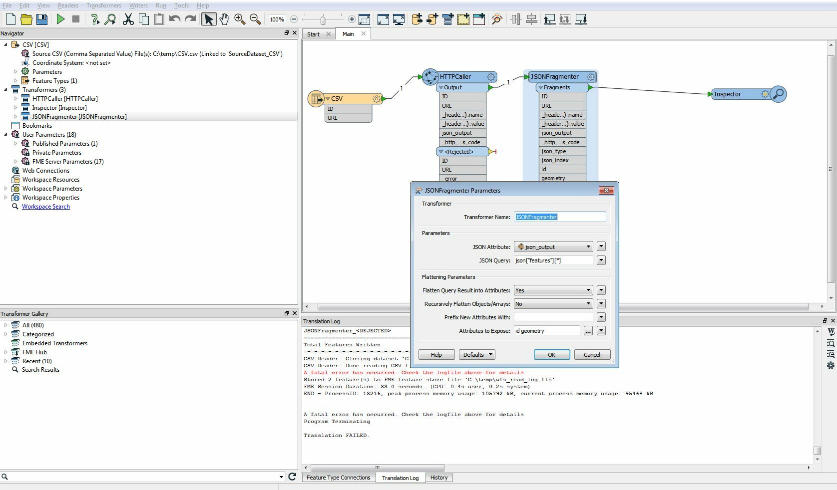
I'm trying to create (FME-)features from a JSON-ouput (source: JSONFragmenter).

I am not able to subtract/expose "geometry" and can't figure out why.

My JSONFragmenter parameters are:

JSON Query: json<"features"]

  • Attributes to expose: id geometry

    Can someone help me out ?
    0684Q00000ArD10QAF.jpg

    Example of JSON-output:

    {
        "type": "FeatureCollection",
        "totalFeatures": 1681523,
        "features": o
            {
                "type": "Feature",
                "id": "GBG.23662",
                "geometry": {
                    "type": "Polygon",
                    "coordinates":  
                        Â
                             
                                134465.638337,
                                192310.473928
                            ],
                            Â
                                134465.881025,
                                192308.624072
                            ],
                            9
                                134470.076353,
                                192309.29684
                            ],
                            Â
                                134470.049217,
                                192308.49812
                            ],
                            Â
                                134474.971585,
                                192308.162248
                            ],
                             
                                134475.428289,
                                192311.290056
                            ],
                             
                                134472.498625,
                                192311.514824
                            ],
                            0
                                134472.445377,
                                192310.982344
                            ],
                             
                                134470.684609,
                                192311.168712
                            ],
                            Â
                                134465.638337,
                                192310.473928
                            ]
                        ]
                    ]
                },
                "geometry_name": "SHAPE",
                "properties": {
                    "UIDN": 334345,
                    "OIDN": 294586,
                    "TYPE": 2,
                    "LBLTYPE": "bijgebouw",
                    "OPNDATUM": "2005-09-05",
                    "bbox":  
                        134465.638337,
                        192308.162248,
                        134475.428289,
                        192311.514824
                    ]
                }
            },

  • I don't have an immediate answer for you, but it looks like the output might be similar to what's discussed here.


    Hi @sdv, you have to flatten the JSON fragment to extract the members. Check these parameters in the JSONFragmenter.

    • Flatten Query Result into Attributes: Yes
    • Recursively Flatten Objects/Arrays: Set "Yes" if you need to flatten all descendant objects, "No" otherwise (flatten only one-level).

    By the way, the document seems to be a GeoJSON dataset. You can also read it with the GeoJSON reader as features having a geometry and a set of attributes.


    I don't have an immediate answer for you, but it looks like the output might be similar to what's discussed here.

    Thank you for following up my question redgeographics . Indeed I have tried to study that topic to put me on the right track !


    Hi @sdv, you have to flatten the JSON fragment to extract the members. Check these parameters in the JSONFragmenter.

    • Flatten Query Result into Attributes: Yes
    • Recursively Flatten Objects/Arrays: Set "Yes" if you need to flatten all descendant objects, "No" otherwise (flatten only one-level).

    By the way, the document seems to be a GeoJSON dataset. You can also read it with the GeoJSON reader as features having a geometry and a set of attributes.

    @takashi


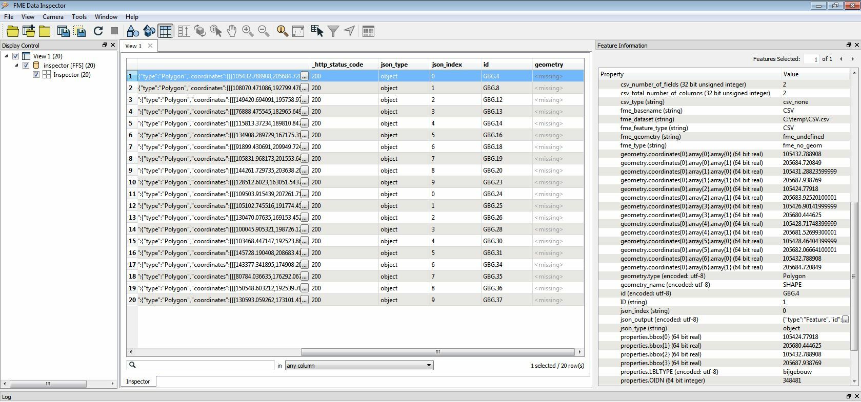
    This is how my workbench looks now


    Now I'm able to see a 'geometry' field.


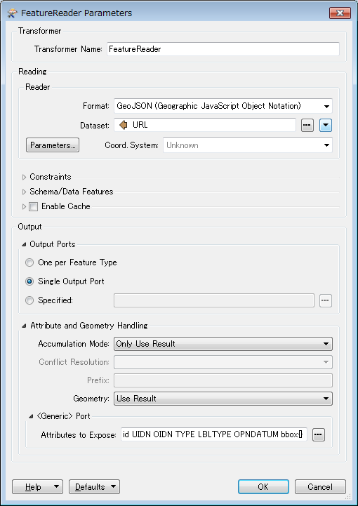
    Just one (stupid...) question: can I use the FeatureReader to read the outcome of the JSONFragmenter ? I'm quite new to FME + can't seem to configure the FeatureReader for my purposes. Thanks !


    Hi @sdv, you have to flatten the JSON fragment to extract the members. Check these parameters in the JSONFragmenter.

    • Flatten Query Result into Attributes: Yes
    • Recursively Flatten Objects/Arrays: Set "Yes" if you need to flatten all descendant objects, "No" otherwise (flatten only one-level).

    By the way, the document seems to be a GeoJSON dataset. You can also read it with the GeoJSON reader as features having a geometry and a set of attributes.

    If you intend to read the dataset as a GeoJSON document, I think just a single FeatureReader is what you need. Try connecting this FeatureReader to the CSV reader feature type directly.


    Reply