Solved

Show metadata on autocad/civil blocks

  • October 25, 2017
  • 8 replies
  • 132 views

lars_de_vries
Forum|alt.badge.img+10

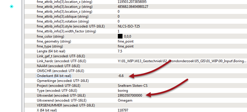
Within AutoCAD / Civil3D it is possible to add metadata on block definitions, not being attributes. Somehow I cannot access these metadata fields in FME. Does any one have a solution for that?

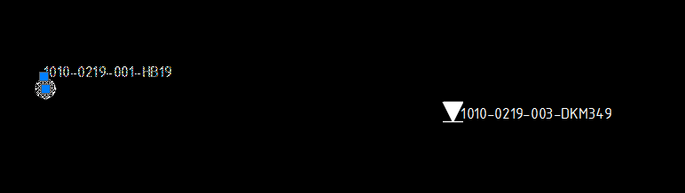
Figure 1. Blocks with attributes, this information is accessible within FME.


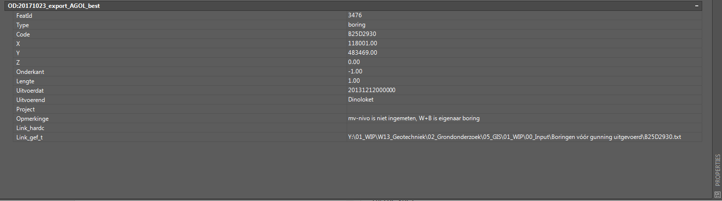
Figure 2. Metadata information of selected block shown in Figure 1.


I have tried enabling user defined properties and XDATA, but somehow I cannot acces the metadata.

I am using FME2017.1.1.

The final goal is to write these metadata properties into a new dwg. I know I can add these as attribute properties to the block definition, but that is not what the user wants as its final result.

Added you'll find the example DWG.

Best answer by mark2atsafe

Yes, if you read the data with the Map 3D Object Data reader (64-bit FME only) then you will get attributes for these features:

So I suspect if you use the Map 3D writer you'll be able to write these out too.

View original
Did this help you find an answer to your question?

8 replies

nielsgerrits
VIP
Forum|alt.badge.img+54

Looks like Object Data to me. You should be able to read this with the Autodesk AutoCAD Map 3D Object Data reader. I can't find the fields in the sample you attached tho...


mark2atsafe
Safer
Forum|alt.badge.img+44
  • Safer
  • October 26, 2017
I see an existing enhancement request (PR#11157) that asks to "add support for standardized XML Metadata". On the assumption that this is the same thing, then it looks like we don't currently support this. But I've asked the developers for confirmation of that and will let you know what they say.


fmelizard
Safer
Forum|alt.badge.img+18
  • Safer
  • October 26, 2017
Hello. Can you please clarify what application is being used, and what interface or command is being used to see those data attributes in Figure 2? They are not apparent in the attached drawing, with expected tools and inspection. Thanks.


lars_de_vries
Forum|alt.badge.img+10


@reganproulx Hi, I expect that Autocad Civil3D has been used to look at this information.


lars_de_vries
Forum|alt.badge.img+10
lars_de_vries wrote:


@reganproulx Hi, I expect that Autocad Civil3D has been used to look at this information.


The first drawing did not contain the extra information. The newly attached drawing does. gis-input-test2.dwg


In this case a shapefile was imported in an autocad dwg drawing. The Autocad Map3D function MAPIMPORT has been used to attach the information, which comes available in some kind of Object Definition, which cannot be accessed with FME.


mark2atsafe
Safer
Forum|alt.badge.img+44
  • Safer
  • Best Answer
  • October 30, 2017

Yes, if you read the data with the Map 3D Object Data reader (64-bit FME only) then you will get attributes for these features:

So I suspect if you use the Map 3D writer you'll be able to write these out too.


lars_de_vries
Forum|alt.badge.img+10
mark2atsafe wrote:

Yes, if you read the data with the Map 3D Object Data reader (64-bit FME only) then you will get attributes for these features:

So I suspect if you use the Map 3D writer you'll be able to write these out too.

I still need to test your suggestion, but I expect that it will be allright.


lars_de_vries
Forum|alt.badge.img+10

Thanks everyone for your input!


Cookie policy

We use cookies to enhance and personalize your experience. If you accept you agree to our full cookie policy. Learn more about our cookies.

 
Cookie settings