Hello,
I have global data read in from PostGIS which I want to clip out to any one of the 5000+ coordinate reference systems (the end user might request anything) and then export to FileGDB, Shapefile or Landmark Z-Map Grid. The data is in WGS84, clipped in WSG84, and then reprojected. Some data reprojects fine (maybe based on the CRS) but others don't and I can't see why.
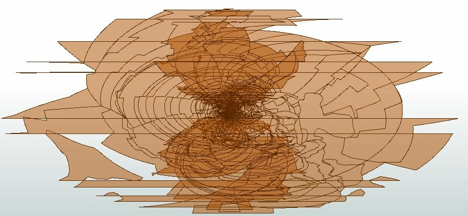
The example image below shows some data that is projected into Minna.NigeriaMid projection. In the original data, the entire earth is covered by data, but no polygons overlap. Clearly, after reprojection they do. I believe most overlaps are caused by the data being 180 degrees away from the central meridian of the Minna.NigeriaMid projection, but cannot think of a way to easily get around this. If there was a way to find the central meridian of the projection the user requests and cut the clipper 180 degrees from that, it might solve the issue?
I have cut my clipper area so it doesn't go beyond -179.99, -89.99 etc., and I have tried projecting to from WGS84 to LL-360 and then to Minna.NigeriaMid as suggested in this post but this didn't work. https://knowledge.safe.com/articles/34013/dateline-problem.html
I have tried reading in the data (WGS84) and then reprojecting both the data and the clipper to my new projection before clipping, to no avail. I'm also always getting this message when reprojecting:
"Conversion outside of usable range of Multiple Regression definition; using fallback definition."
I think I might also look into the option of clipping the data in the PostGIS reader.
There will also be raster data for reprojecting which I'm sure will cause more headaches!