I have a workbench that tries to write features to an existing hosted feature layer in ArcGIS Online and also to an enterprise geodatabase. The enterprise GDB write is successful but the AGOL write fails with some odd errors about needing to reproject the data (which makes sense since AGOL uses WGS 84 Web Mercator Aux Sphere and my data uses our local StatePlane projection). I added a Reprojector transformer (tried both the regular Reprojector and the ESRIReprojector) and both don't solve the issue.
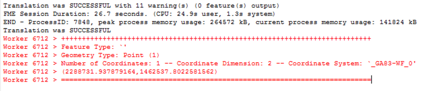
What makes this really weird is that in earlier steps in my workbench, when I click on the inspector icon in any transformer available, the visual preview shows up for about a second, then suddenly the transaction log pops up and shows "Worker <some 4 digit number that always changes>" then a few lines of generic info about coordinates of a single record. Here's an example:
Are these issues related? Am I doing something really wrong?
Best answer by nick30097
@palhermans Thanks for the suggestion. The solution was a little more complicated to solve than I anticipated, but did involve some extra work.
The problem I was having came as a result of the differences between FME and Esri's naming conventions for projections. According to Esri Tech Support, if you're using FME as part of ArcGIS Pro/ ArcMap, then you also should install the Coordinate System Data package that comes as a separate install. In my case, I'm using ArcGIS Pro 2.4 and this required downloading the package specific to this version. Then when you configure the input projection for each reader and output projections for each writer, you should specify the projection using the WKID number, rather than picking from the list of projections in FME. This is because FME and ArcGIS Pro don't use the same naming conventions for projections. This only presented as a problem because I was using the ESRIReprojector transformer (which relies on the Esri software to do the reprojecting) and I was specifying FME projection names.
Hi, I tried ESRI Reprojector with that point (2288731, 1462537) and source-system NAD_1983_StatePlane_Gorgia<etc> and destination-system as "Mercator Aux Sphere" and have no problem inserting into an existing AGOL layer.
Maybe a installation problem as you are seeing strange behavior with the Data Inspector (a wild guess?)
@palhermans Thanks for the suggestion. The solution was a little more complicated to solve than I anticipated, but did involve some extra work.
The problem I was having came as a result of the differences between FME and Esri's naming conventions for projections. According to Esri Tech Support, if you're using FME as part of ArcGIS Pro/ ArcMap, then you also should install the Coordinate System Data package that comes as a separate install. In my case, I'm using ArcGIS Pro 2.4 and this required downloading the package specific to this version. Then when you configure the input projection for each reader and output projections for each writer, you should specify the projection using the WKID number, rather than picking from the list of projections in FME. This is because FME and ArcGIS Pro don't use the same naming conventions for projections. This only presented as a problem because I was using the ESRIReprojector transformer (which relies on the Esri software to do the reprojecting) and I was specifying FME projection names.
Glad to hear that you got this resolved, and thanks for sharing what worked for you!
I am using FME ESRI Esition and have always had the ESRIReprojector and hence the Coordinate System Data package available. After some bad experiences with (Safe) Reprojector (one bug, limited capabilities of the Gauss-Krüger/Transversal Mercator) I have sort of ended up using "ESRI only" in this domain for my workspaces (with some exceptions as always). Thanks for sharing your fix.
We use 3 different kinds of cookies. You can choose which cookies you want to accept. We need basic cookies to make this site work, therefore these are the minimum you can select. Learn more about our cookies.