Question

Project from LL-27 to EPSG 3857 Web Mercator


messagemauri
Contributor
Forum|alt.badge.img+6

FME Desktop 2021

Data Source is in LL-27


I get a lines dataset in LL-27 and points dataset in LL-27. My objective is to shows these lines and points on a Map that is in Web Mercator, EPSG:3857.


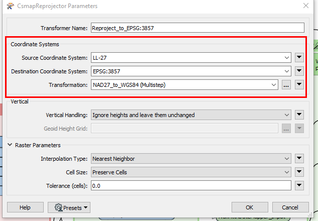
I currently use the CsmapReprojector and I have the following configuration:


Source Coordinate System: LL-27

Destination Coordinate System: EPSG: 3857

Transformation: NAD27_to_WGS84 (Multistep)


When I write the output for the lines and points to a Shapefile and place them in a Map in Web Mercator, the lines and points align and connect as expected, however, the problem is that their map positioning is slightly off from the actual Lat Long values that they should fall on.


Is there another 'Transformation' I should be using to get them properly positioned on the map (map in Web Mercator)?


image 

Thanks for your time. Much appreciated.


2 replies

daveatsafe
Safer
Forum|alt.badge.img+19
  • Safer
  • May 1, 2023

Hi @messagemauri​,

Your original lat/long values are in NAD27, while the lat/long values shown in the Map will be in WGS84, as used in EPSG:3857. Due to the different ellipsoids used by these datums, the lat/long values will be different.


messagemauri
Contributor
Forum|alt.badge.img+6
  • Author
  • Contributor
  • May 1, 2023
daveatsafe wrote:

Hi @messagemauri​,

Your original lat/long values are in NAD27, while the lat/long values shown in the Map will be in WGS84, as used in EPSG:3857. Due to the different ellipsoids used by these datums, the lat/long values will be different.

@daveatsafe​  , Thank you very much for your reply and explanation.


Cookie policy

We use cookies to enhance and personalize your experience. If you accept you agree to our full cookie policy. Learn more about our cookies.

 
Cookie settings