Solved

Problem using Dissolver with large shape files - corrupt KML files created


Hi

I have a file of UK postcode areas which I am attempting to merge to create a themed overlay on a Google Map. However, it appears that in merging the polygons from the shp file, some of the polygon boundary line-string point ordering gets messed up so that there are "figures of eight" in the resulting KML file.

I suspect the problem may be linked to the order of shapes in the original shp file, so is there a transformer I can use to improve the dissolver functionality.

Note that the inspector view of the output is correct, it is just when "kml_360" polygon is viewed, it has "steaks" across the area.

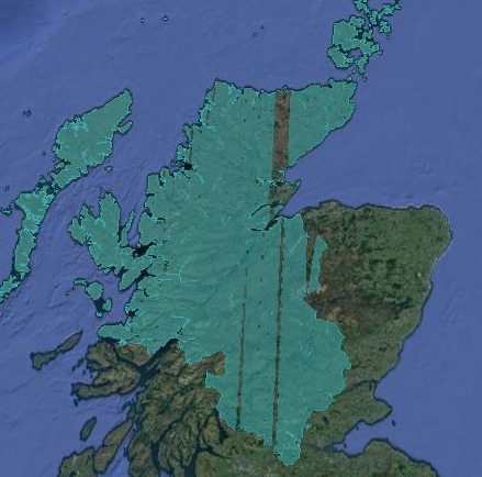
I have attached the source files used to create this sample. The image is OK when viewed by the inspector.

Thoughts on how to resolve this issue welcome or additional transformers which can be used in the data processing pipeline to mitigate the problem

Best answer by mark_f

I recently had a similar issue but the GeometryValidator didn't help. The issue could be precision in the SHP file where polygon edges are VERY close but not exact.


Try adding a AreaOnAreaOverlayer before the Dissolver transformer, then set the parameter on the Dissolver to "Assume Input is Clean" = Yes. A Snapper transformer can also work. I found a CoordinateRounder rounding to high number of decimal places worked too.


View original
Did this help you find an answer to your question?

4 replies

itay
Supporter
Forum|alt.badge.img+17
  • Supporter
  • May 11, 2017

Use the GeometryValidator to correct the self intersections.


Forum|alt.badge.img+2
  • Best Answer
  • May 11, 2017

I recently had a similar issue but the GeometryValidator didn't help. The issue could be precision in the SHP file where polygon edges are VERY close but not exact.


Try adding a AreaOnAreaOverlayer before the Dissolver transformer, then set the parameter on the Dissolver to "Assume Input is Clean" = Yes. A Snapper transformer can also work. I found a CoordinateRounder rounding to high number of decimal places worked too.


  • Author
  • May 11, 2017

Thanks Mark@mark_1spatial and @itay. I found that running the geographic dataset through Snapper resolved the issue by eliminating any differences in the polygon verticies.


fmelizard
Safer
Forum|alt.badge.img+19
  • Safer
  • May 15, 2017
davewp wrote:

Thanks Mark@mark_1spatial and @itay. I found that running the geographic dataset through Snapper resolved the issue by eliminating any differences in the polygon verticies.

Hi @davewp -- if you'd be willing to send in the original dataset and workspace to us via support@safe.com -- we'd love to look more closely. FME 2018 will have more levers for robust dissolve and this sounds like an excellent test case. Thanks (and sorry for the troubles)


Cookie policy

We use cookies to enhance and personalize your experience. If you accept you agree to our full cookie policy. Learn more about our cookies.

 
Cookie settings