Hi @spiderman
Can you verify if you are referring to the OSM PBF format?
FME Desktop has this format reader available OpenStreetMap (OSM) Protocolbuffer Binary Format (PBF)
and OpenStreetMap (OSM) XML Reader
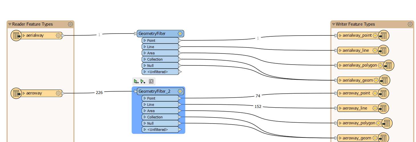
The best practice would be to use GeometryFilter as Shapefile can only handle a single geometry type.
Using Generate workspace would automatically do this for you and create shapefiles based on various geometry types i.e. aeroway_line, aeroway_point, aeroway_polygon. This feature may contain both Point and Line geometries so you will have two shapefiles.
Thanks for ur reply ,any format valid for OSM ,will be okey for me but i am using PBf FORMAT .i did as ur opinion but i am not satisfied with this output .because i would like to get output for polygon as it shows in google maps but i found it looks different in colors .
how could i achieve the output as google maps ?
could you please provide an example for specific city ,also i am not sure how to choose specific coordinates for specific city
i am sry iam beginner and first time use OSM at workspace
Thanks for help
Hi @spiderman
Can you explain what application you are using it creates a background map?
Ideally, each application gives you options to pick the color for polygons individually or set color use.
To display a map similar to Google Maps, you will need the following layer (at minimum)
Landuse polygons
Transport Lines
Railways Lines
Waterways polygons
Buildings polygons
However, the Geofabrik Download server (https://download.geofabrik.de/europe/germany/berlin-latest-free.shp.zip) provides shapefile as well if you prefer to use those, I am using Berlin as a sample here.
For Legend, you may have to manually map the legend based on and set the value of fme_color based o the information provided here https://blog.google/products/maps/google-maps-gets-new-look/
Hi @rahulsharma
Thanks for ur reply , sry for reply late but i was sick last week .
i got what u mean ,but i am looking for it but i could not get this point .
i have downloaded from geofabrik ,some of cities ,how could i extract polygon that i want .
as example ,i have data from GIS for some cities so i tried to use spatial relator to extract same coordinates of polygon from Openstreet map but spatial relator did not get output and it gone to rejected .
so my questions , how could i extract specific polygon of one city when i have several cities ?
and also is it best site to download osm is geofabrik or which site od you prefer ?
Thanks for ur reply ,any format valid for OSM ,will be okey for me but i am using PBf FORMAT .i did as ur opinion but i am not satisfied with this output .because i would like to get output for polygon as it shows in google maps but i found it looks different in colors .
how could i achieve the output as google maps ?
could you please provide an example for specific city ,also i am not sure how to choose specific coordinates for specific city
i am sry iam beginner and first time use OSM at workspace
Thanks for help
The PBF contains the raw data, if you want it to look like, for example, Google Maps you'll need to style the data. Within FME you can use the MapnikRasterizer and write the output to a raster format. When it comes to cartographic output you can also consider doing that in a GIS application as they offer some more tools than FME. Be warned though, this will be a lengthy process and basically involves splitting up the data in categories and applying a style to each of those.
Thanks for ur reply ,any format valid for OSM ,will be okey for me but i am using PBf FORMAT .i did as ur opinion but i am not satisfied with this output .because i would like to get output for polygon as it shows in google maps but i found it looks different in colors .
how could i achieve the output as google maps ?
could you please provide an example for specific city ,also i am not sure how to choose specific coordinates for specific city
i am sry iam beginner and first time use OSM at workspace
Thanks for help
thanks for ur reply , how could i extract one polygon from many lots of polygons in OSM shape file .which transformer should i use?
and it means that for each city should i have to do it by myself in gis application ,is there no way to let FME to color cartographic output automatic .
which site are you using to download OSM shape file ?
Hi @rahulsharma
Thanks for ur reply , sry for reply late but i was sick last week .
i got what u mean ,but i am looking for it but i could not get this point .
i have downloaded from geofabrik ,some of cities ,how could i extract polygon that i want .
as example ,i have data from GIS for some cities so i tried to use spatial relator to extract same coordinates of polygon from Openstreet map but spatial relator did not get output and it gone to rejected .
so my questions , how could i extract specific polygon of one city when i have several cities ?
and also is it best site to download osm is geofabrik or which site od you prefer ?
Hi @spiderman
The first thing to check is the Coordinate system, OSM is WGS-84, while Google Maps are in Spherical Mercator.
Can you confirm the coordinate system of the cities that you are trying to overlay/relate to?
Ideally, you want the data that you are performing Spatial operations should have the same coordinate system.
Hi @rahulsharma
Thanks for ur reply , sry for reply late but i was sick last week .
i got what u mean ,but i am looking for it but i could not get this point .
i have downloaded from geofabrik ,some of cities ,how could i extract polygon that i want .
as example ,i have data from GIS for some cities so i tried to use spatial relator to extract same coordinates of polygon from Openstreet map but spatial relator did not get output and it gone to rejected .
so my questions , how could i extract specific polygon of one city when i have several cities ?
and also is it best site to download osm is geofabrik or which site od you prefer ?
reading from features LL-83 ,i have already converted OSM wgs-84 to this coordinate of cities .
but the problem i found when i do spatial relator that it goes rejected ,the reason invalid geometry base for some input.i think so .or which transformer should i think to do .
could you please provide an exampe with shape file berlin that you have uploaded before.thanks
Hi @spiderman
I was wondering if you will be able to share your workspace and data.
If the data is in the same projections (and same city), SpaitalFilter/Relator should work.