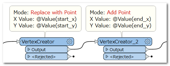
Hi, I have a non-spatial SQL dataset containing a unique identifier along with 2 sets of coordinates (start x and y, end x and y). I am using 2 vertex creators to spatially enable the data and then want to draw lines between the coordinates, separated by each unique identifier. However, using the LineBuilder the output is only coming out of the Point port and nothing is coming out of the Line output port. The workspace worked previously using Desktop 2018, the only difference now is I am using 2020 with updated SQL data, though the data type is unchanged.
Solved
Line Builder not working correctly?
Best answer by takashi
Hi @lifeinabox , if each feature has two sets of coordinates - start (x, y) and end (x, y), and you need to create a single line segment connecting the start point and the end point, you can do it just using two VertexCreators (Replace with Point mode and Add Point mode) connected in a series.
 "Add Point" is available too in the first VertexCreator, since the input feature from Non-Spatial SQL doesn't have any geometry in this case.
This post is closed to further activity.
It may be an old question, an answered question, an implemented idea, or a notification-only post.
Please check post dates before relying on any information in a question or answer.
For follow-up or related questions, please post a new question or idea.
If there is a genuine update to be made, please contact us and request that the post is reopened.


