Hi I am trying to convert a data set:


http://www.biz-gis.com/GISDB/


3rd one down on the left (Dong Boundaries) and I have tried all the Korean projections in FME but it does not seem to locate it in the right place - do I need to widen my Proejction search or does any know which one it is - it mentions Transverse Mercator but that's as far as I have got?


Hi,


What is your intention? do you want to reproject the data into a new coordinate system?


You can use the CoordinateSystemExtractor to retrive the data's coordinate system. 
many thanks for the reply - yes I want to convert it to WGS84 LL but the if I don't state the projection on the reader it does not find it, likewise the CoordinateSystemExtractor returns a null value, I have used a different piece of software to get the data to map it very close to the correct location - but has some slight warping, but ideally I want to use FME as we have other files to process.


If FME returns no proejction from CoordinateSystemExtractor does it mean FME does not support the projection of the source file?


Since it is a shape without the .prj extension, FME cannot recognize the data projection.


I have managed to use the reprojector even without projection. It is not always necesarry to know what the origin coord sys is
but then again crap in crap out......
Hi,


is it possible to contact the data owners and ask for the projection details, perhaps? Even if you were to find a projection that matches, you might still introduce subtle errors in parts of your data, unless you found the exact same match.


I tried to set the projection to "KOREA" in FME2013 and applied an Offsetter with X: 300000 and Y: -300000 and the results seemed rather plausible.


David
Hi,


I saw the data and western Japan area together on ArcGIS. This *.prj definition predefined in ArcGIS is probably match (may not be exact).   PROJCSJ"Korean_1985_Korea_Central_Belt",GEOGCSG"GCS_Korean_Datum_1985",DATUMT"D_Korean_Datum_1985",SPHEROIDO"Bessel_1841",6377397.155,299.1528128]],PRIMEMM"Greenwich",0.0],UNITN"Degree",0.0174532925199433]],PROJECTIONI"Transverse_Mercator"],PARAMETERT"False_Easting",200000.0],PARAMETERT"False_Northing",500000.0],PARAMETERT"Central_Meridian",127.0],PARAMETERT"Scale_Factor",1.0],PARAMETERT"Latitude_Of_Origin",38.0],UNITN"Meter",1.0]]   Even though this definition is exact, FME doesn't seem to support it by default. I think you will have to define a custom coordinate system. http://docs.safe.com/fme/html/FME_Workbench/Default.htm#About_Custom_Coordinate_Systems.htm


Takashi
Additional information:


http://spatialreference.org/ref/epsg/2097/
Takashi, I suspect the SRS you posted is identical to the "KOREA" entry in FME.


David
David, there are some differences between FME "KOREA" and "Korean_1985_Korea_Central_Belt".


Korea, Kor127TM (FME: KOREA) FME Coordinate System Gallery > Coordinate System Properties (KOREA) ----- PROJCSC"Korea, Kor127TM",     GEOGCSO"TOKYO-M",         DATUMÂ"TOKYO-M",             SPHEROIDÂ"Bessel, 1841",6377397.155,299.1528153513275]],         PRIMEMÂ"Greenwich",0],         UNIT0"degree",0.0174532925199433]],     PROJECTION3"Transverse_Mercator"],     PARAMETER&"latitude_of_origin",38],     PARAMETERq"central_meridian",127],     PARAMETER&"scale_factor",1],     PARAMETERc"false_easting",500000],     PARAMETERg"false_northing",199746.17],     UNITt"METER",1]] ----   Korean_1985_Korea_Central_Belt (EPSG:2097) Spatial Reference epsg projection 2097 - korean 1985 / korea central belt http://spatialreference.org/ref/epsg/2097/ ----- PROJCSg"Korean 1985 / Korea Central Belt",     GEOGCSo"Korean 1985",         DATUMq"Korean_Datum_1985",             SPHEROIDa"Bessel 1841",6377397.155,299.1528128,                 AUTHORITY7"EPSG","7004"]],             AUTHORITYo"EPSG","6162"]],         PRIMEMA"Greenwich",0,             AUTHORITYÂ"EPSG","8901"]],         UNITÂ"degree",0.01745329251994328,             AUTHORITYÂ"EPSG","9122"]],         AUTHORITY "EPSG","4162"]],     UNITt"metre",1,         AUTHORITYq"EPSG","9001"]],     PROJECTION;"Transverse_Mercator"],     PARAMETER&"latitude_of_origin",38],     PARAMETERT"central_meridian",127],     PARAMETER;"scale_factor",1],     PARAMETERT"false_easting",200000],     PARAMETERM"false_northing",500000],     AUTHORITY["EPSG","2097"],     AXISA"Y",EAST],     AXIS;"X",NORTH]] -----


After appending *.prj file to downloaded Korean shapefile, I projected them on ArcMap.


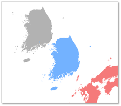
Data Frame Coordinate System: UTM-52N Gray: Korea, Kor127TM (FME "KOREA") Blue: Korean_1985_Korea_Central_Belt (EPSG:2097) Pink: Japan, LL-WGS84


Result, blue Korea seems to be located correctly, gray Korea is too far away from Japan!


In addition, GIS data (LL-WGS84) of each country can be downloaded here.


Global Administrative Areas > download


http://www.gadm.org/country


Takashi


The coordinate system I provided is just a guessing based on map browsing. Although it looks good, I cannot guarantee that it's correct.


You should contact to the data provider as David mentioned, if possible.
Thanks for the screenshot, Takashi, very illustrating.


David
thanks for the feedback some good options here I I like the idea of creating a custom proejction in FME - as our custom projection so far has had the best fit using the extents of the bounds and some offsetting.


Reply