Question

Issue Reprojecting Shapefile from SIRGAS 2000 to WGS84 in FME

  • September 3, 2025
  • 5 replies
  • 48 views

francisco_1988
Contributor
Forum|alt.badge.img+5

Hello everyone,

I’m having trouble reprojecting a shapefile. The file is currently in SIRGAS 2000, and I need to convert it to WGS84. However, when I run the reprojection, an error occurs (see attached image).

Additionally, I need to extract the current coordinate system of the shapefile. In the table, the field shows up as _FME_0, but it should display SIRGAS 2000.

Does anyone know how to fix these two issues?

5 replies

hkingsbury
Celebrity
Forum|alt.badge.img+64
  • Celebrity
  • September 3, 2025

Have you tried setting the Source Coordinate System in the Reprojector to SIGRAS 2000?

It seems the FeatureReader isn’t correctly reading the coordinate system


francisco_1988
Contributor
Forum|alt.badge.img+5
  • Author
  • Contributor
  • September 3, 2025

Have you tried setting the Source Coordinate System in the Reprojector to SIGRAS 2000?

It seems the FeatureReader isn’t correctly reading the coordinate system

I need the shape writer to be dynamic, as I need to read shapefiles in different projections.


takashi
Celebrity
  • September 4, 2025

Instead of EsriReprojector, how about using another reprojector transformer - e.g. Reprojetor or CsmapReprojector?


francisco_1988
Contributor
Forum|alt.badge.img+5
  • Author
  • Contributor
  • September 4, 2025

Instead of EsriReprojector, how about using another reprojector transformer - e.g. Reprojetor or CsmapReprojector?

Hi Takashi! In the example I sent as an attachment, I'm already using Reprojector. Do you recommend using ESRI Reprojector? Is that what you meant?


takashi
Celebrity
  • September 4, 2025

Oh, I got it wrong.

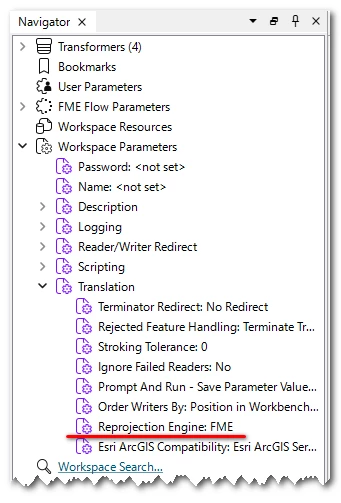
Try changing the Reprojection Engine parameter of the workspace from Esri to FME and resetting the Destination Coordinate System parameter in the Reprojector to "LL-WGS84" or "EPSG:4326".