Hi, I have a need to set ImageRasterizer's ground extents based on one of the DWG layers bounding box! Is it possible? Please tell me so! It's a deal breaker for me to decide if FME is usable for us.

Solved
ImageRasterizer's ground extents based on some data?
Best answer by takashi
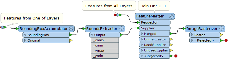
Hi @theodolite3, you can use the BoundingBoxAccumulator to create the bounding box enclosing all features in the layer and extract its extents (xmin, ymin, xmax, ymax) with the BoundsExtractor. Then, merge the extents attributes to all the features unconditionally with the FeatureMerger (set an identical constant e.g.1 to the Join On parameter), send the Merged features to the ImageRasterizer, and set the extents to the Ground Extents parameters.
This screenshot illustrates my intention.
This post is closed to further activity.
It may be an old question, an answered question, an implemented idea, or a notification-only post.
Please check post dates before relying on any information in a question or answer.
For follow-up or related questions, please post a new question or idea.
If there is a genuine update to be made, please contact us and request that the post is reopened.


Login to the community
No account yet? Create an account
An FME Account is required to contribute
LoginEnter your E-mail address. We'll send you an e-mail with instructions to reset your password.