Question

I have a road element and table with distance measurement (only Meters). I want to create point on the line based on the distance value from the table.

  • November 28, 2020
  • 6 replies
  • 39 views

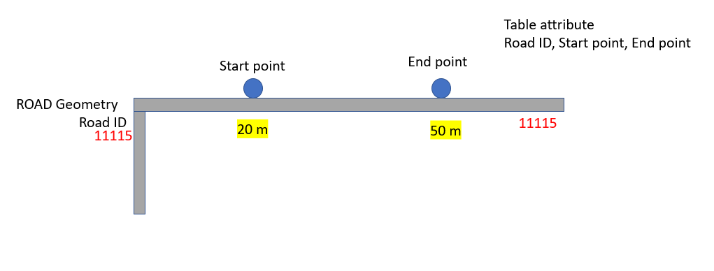
Road is aggregated based on Road ID, that I have in the table as well. So for example I want to create point in X meters ( X value from table) . Snipper is not working for this task. Any solution for this?

Thank you 

This post is closed to further activity.
It may be an old question, an answered question, an implemented idea, or a notification-only post.
Please check post dates before relying on any information in a question or answer.
For follow-up or related questions, please post a new question or idea.
If there is a genuine update to be made, please contact us and request that the post is reopened.

6 replies

hkingsbury
Celebrity
Forum|alt.badge.img+63
  • Celebrity
  • 1625 replies
  • November 29, 2020

once you've aggregated your lines, are you sure the vertices are all in order? The first vertex of the line might not actually be at the start of the line.


Another transformer to look at will be the linecombiner


hkingsbury Thank you for your answer. To be more precise I have a table with no XY, Only Meters(start and end point)and Road Id value. Also, Road geometry with only Road Id attribute. I tried Line combiner and snipper still gives very weird output, instead of creating points on based the measurement, it creates points on every road with no rules.  

12222222222222222222222222222222Snipper Output:

22222222222222222222222222222222222222222222222


ebygomm
Influencer
Forum|alt.badge.img+44
  • Influencer
  • 3427 replies
  • November 30, 2020

Are you looking at creating points that are coincident with the line, or additional vertices within the line?


For the former, I'd generate a measure on the line, then use a snipper using Measure Value mode to snip the line to a point (if you use the same start and end location you will get a point). So you'd need two snippers to get start and end points.


Forum|alt.badge.img+2
  • 1891 replies
  • November 30, 2020

@gisgis2014devel​  I think you're on the right track with Snipper. You need to join each event to the road segment (FeatureJoiner) using your RoadID. Then use Snipper. this will give you the event segments. These can be tied back to the original route with NeightbourFinder . If you don't want the event segments and only the points, Snipper can use the same value for from/to to give a point, and again, NeighbourFinder can be used t tie that back to the road and insert the vertex (or AnchorSnapper)


Are you looking at creating points that are coincident with the line, or additional vertices within the line?


For the former, I'd generate a measure on the line, then use a snipper using Measure Value mode to snip the line to a point (if you use the same start and end location you will get a point). So you'd need two snippers to get start and end points.

Thank you for your reply. Yes, creating points that are coincident with the line. I think complex road geometry gives that unwanted output.


trevorm
Contributor
Forum|alt.badge.img+3
  • Contributor
  • 23 replies
  • December 7, 2021

Hi, searching for like minding request I found this post again. Here is my way of doing this.

Two features:

Network LRS with geomtry and m (measure) in the table is Roadname

Event table (line type) with Roadname and MeasureFrom and measureTo fields no geometry

Using Event Geometry transformer:


now if that makes the lines you want, finish it off with LRS_GetRouteMeasure which will give you the Event From Measure and To Measure in fields and my favorite the From X, From Y , To X , To Y fields also.

image.png