- I have multiple layers in my GDB
- I know I can get the correct projection using share from arcgis pro, but I don't have an arcgis pro subscription for this account, only arcgisonline
- I will need to keep updating the layers keeping the projection in arcgisonline 28992
- thank you in advance for your help

Solved
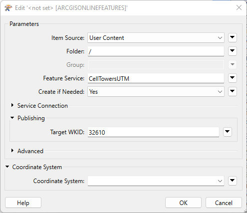
I have a geodatabase that I want to upload to arcgisonline. I set the projection to be 28992 but when I check the projection in AGOL, it will always be Spatial Reference: 102100 (3857). I would like it to be 28992. Is there any way to do this from FM
Best answer by markatsafe
@ionveronica87 if you set the Target WKID or Coordinate System, then FME should create the Feature Class with the desired spatial reference.
This post is closed to further activity.
It may be an old question, an answered question, an implemented idea, or a notification-only post.
Please check post dates before relying on any information in a question or answer.
For follow-up or related questions, please post a new question or idea.
If there is a genuine update to be made, please contact us and request that the post is reopened.


Login to the community
No account yet? Create an account
An FME Account is required to contribute
LoginEnter your E-mail address. We'll send you an e-mail with instructions to reset your password.