Solved

I have a geodatabase that I want to upload to arcgisonline. I set the projection to be 28992 but when I check the projection in AGOL, it will always be Spatial Reference: 102100 (3857). I would like it to be 28992. Is there any way to do this from FM


  • I have multiple layers in my GDB
  • I know I can get the correct projection using share from arcgis pro, but I don't have an arcgis pro subscription for this account, only arcgisonline
  • I will need to keep updating the layers keeping the projection in arcgisonline 28992 
  • thank you in advance for your help

Best answer by markatsafe
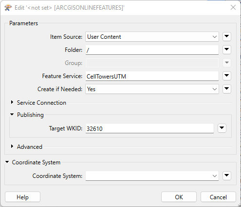
@ionveronica87​ if you set the Target WKID or Coordinate System, then FME should create the Feature Class with the desired spatial reference.

image2

View original
Did this help you find an answer to your question?

4 replies

redgeographics
Celebrity
Forum|alt.badge.img+49

If I'm not mistaken ArcGIS Online uses EPSG:3857 (Web Mercator) by default to store the data and this can't be overridden.


I knew the same until I found out and tested that it can be other than the default projection when using ArcGis Pro to upload. I thought maybe there is a way from FME as well, or maybe anyone else tried to do this and found a solution. Thank you for your reply @Hans van der Maarel​ 


Forum|alt.badge.img+2
  • Best Answer
  • October 12, 2022

@ionveronica87​ if you set the Target WKID or Coordinate System, then FME should create the Feature Class with the desired spatial reference.

image2


markatsafe wrote:

@ionveronica87​ if you set the Target WKID or Coordinate System, then FME should create the Feature Class with the desired spatial reference.

image2

Thank you @Mark Stoakes​  for your help, it worked perfectly!


Reply


Cookie policy

We use cookies to enhance and personalize your experience. If you accept you agree to our full cookie policy. Learn more about our cookies.

 
Cookie settings