Solved

How to report on compression method used in a GeoTiff?

  • May 29, 2025
  • 2 replies
  • 61 views

nicholas
Contributor
Forum|alt.badge.img+14

I am building a workbench that has a GeoTiff Reader, and uses the RasterPropertyExtractor and CoordinateSystemExtractor transformers to report on various qualities of the input image. The bounds, the cell sizes, etc.

I am hoping for a transformer that reports on the compression method of the input image. LZW or JPEG or something else?

Something similar to CoordinateSystemExtractor but instead a CompressionExtractor

Best answer by takashi

Hi ​@nicholas ,

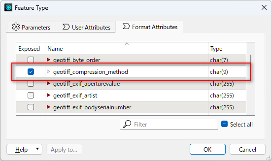
GeoTIFF reader reads the compression method as a format attribute called “geotiff_compression_method”, if the source GeoTIFF file was compressed.


This post is closed to further activity.
It may be an old question, an answered question, an implemented idea, or a notification-only post.
Please check post dates before relying on any information in a question or answer.
For follow-up or related questions, please post a new question or idea.
If there is a genuine update to be made, please contact us and request that the post is reopened.

2 replies

takashi
Celebrity
  • Best Answer
  • May 29, 2025

Hi ​@nicholas ,

GeoTIFF reader reads the compression method as a format attribute called “geotiff_compression_method”, if the source GeoTIFF file was compressed.


nicholas
Contributor
Forum|alt.badge.img+14
  • Author
  • Contributor
  • June 3, 2025

Thankyou ​@takashi 

I took your advice.

I also added a NulAttributeMapper for those cases when the image is not compressed.