
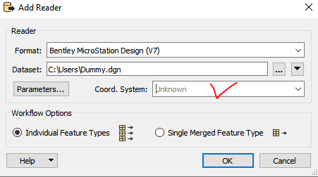
I have DGN file. In Microstation I can see that it had a defined GCS (ETRS89 / UTM zone 32N) When I read the file with FME the coordinate system is not recognised. How do I get FME to read the GCS details?

Solved
How do I read the coordinate reference system in a DGN file?

 +11
+11- Contributor
Best answer by jovitaatsafe
Hi @eric_armitage,
Unfortunately it looks like our Microstation reader/writer format does not currently have support for coordinate systems according to our format documentation. We have an enhancement request tracked internally as (FMEENGINE-9051) to add support for coordinate systems. I've linked this question to it and we'll be back to update when it's been addressed.
For most other formats that do support coordinate systems though, it is definitely possible to set it in the reader or CoordinateSystemSetter if you know the corresponding coordinate system for the dataset.
This post is closed to further activity.
It may be an old question, an answered question, an implemented idea, or a notification-only post.
Please check post dates before relying on any information in a question or answer.
For follow-up or related questions, please post a new question or idea.
If there is a genuine update to be made, please contact us and request that the post is reopened.

 2.
2. 


Login to the community
No account yet? Create an account
An FME Account is required to contribute
LoginEnter your E-mail address. We'll send you an e-mail with instructions to reset your password.