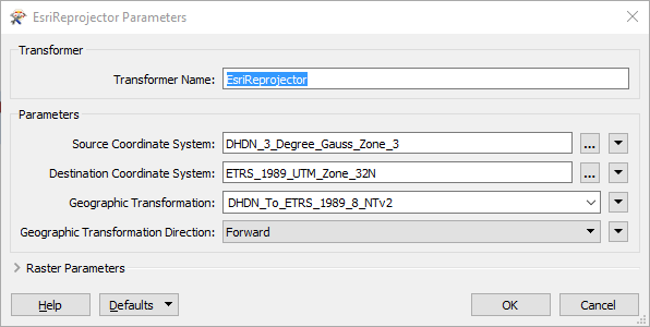
I have installed the FME ESRI Edition (node locked crc) FME(R) 2016.0.1.0 (20160130 - Build 16174 - WIN64) but cannot start the ESRIReprojector. How can I get access to this transformer?

First of all you'll need to install and license the ArcGIS libraries on your machine.

Secondly, since you have the 64-bit edition of FME, you'll have to be extra careful about certain pre-requisites and limitations, see here for more info: https://knowledge.safe.com/articles/1517/notes-on-fme-and-esri-versions-and-compatibility.html


It seems as though the prerequsites have been fulfilled. I have installed ArcGIS Desktop 10.3.1 prior to installing SAFE FME 64bit. The software is fully licenced in "advanced" level.

I cannot see any reason therefore that the ESRIReporojector shouldn´t be available.


ArcGIS Desktop isn't 64-bit (yet), so you'll also have to install the ArcGIS 64-bit Background Geoprocessing. If you look under Tools / Browse readers and writers, you need to see that the ArcGIS formats are licensed and available in FME:

Hopefully that should make it work, if not you'll probably have to ask Safe support for assistance. Or just install the 32-bit edition of FME instead.


Installing ArcGIS Pro is another option


OK....so i installed and licenced ArcGIS Pro 1.2 and have now the ESRIReprojector, but as I am trying to convert from JPG in EPSG:31467 to ECW in EPSG:25832 I need to use a transformation method. It seems that this is not as easy as I expected. There is an input box for the method but no methods are listed to use. How can I set the transformation method to DHDN_To_ETRS_1989_8_NTv2?


OK....so i installed and licenced ArcGIS Pro 1.2 and have now the ESRIReprojector, but as I am trying to convert from JPG in EPSG:31467 to ECW in EPSG:25832 I need to use a transformation method. It seems that this is not as easy as I expected. There is an input box for the method but no methods are listed to use. How can I set the transformation method to DHDN_To_ETRS_1989_8_NTv2?

You need to set the Source and Destination coordinate systems first, as the list of possible geographic transformations depend on it:


Reply