Question

Geometry Data Conversion MDSYS.SDO_GEOMETRY - oracle spatial to SDE.ST_GEOMETRY - ArcGis via FME

  • April 11, 2018
  • 6 replies
  • 215 views

Good Morning!

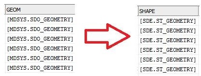
I'm having trouble generating a stream that converts data of type MDSYS.SDO_GEOMETRY (oracle spatial) to SDE.ST_GEOMETRY (arcgis).If it is possible, is there any procedure or manual to perform this activity?

Thanks in advance for your cooperation

Explo:

This post is closed to further activity.
It may be an old question, an answered question, an implemented idea, or a notification-only post.
Please check post dates before relying on any information in a question or answer.
For follow-up or related questions, please post a new question or idea.
If there is a genuine update to be made, please contact us and request that the post is reopened.

6 replies

david_r
Celebrity
  • 8394 replies
  • April 11, 2018

By far the easiest solution is to simply use an Oracle Spatial reader and send everything to an ArcGIS SDE writer. FME should take care of the rest.

Open FME Workbench and select Generate workspace, select your input tables and output database and that's about it.


The problem is when converting the information MDSYS.SDO_GEOMETRY - oracle spatial to SDE.ST_GEOMETRY - ArcGIS, I do not know how to do this conversion.


david_r
Celebrity
  • 8394 replies
  • April 12, 2018

The problem is when converting the information MDSYS.SDO_GEOMETRY - oracle spatial to SDE.ST_GEOMETRY - ArcGIS, I do not know how to do this conversion.

FME does it for you, that's the beauty of FME. Unless you have a very special case, you probably won't have to do anything else but to read the Oracle spatial data and write it to your SDE instance.

roberto
Contributor
Forum|alt.badge.img+6
  • Contributor
  • 48 replies
  • October 3, 2019

By far the easiest solution is to simply use an Oracle Spatial reader and send everything to an ArcGIS SDE writer. FME should take care of the rest.

Open FME Workbench and select Generate workspace, select your input tables and output database and that's about it.

@david_r, Could you suggest how to perform the conversion from sdo_geometry to st_geometry in case we are not using ESRI? This because the field type of a DB we need to integrate uses that datatype and we can't modify it. So far I'm using an oracle query that do the job like ST_POLYGON(SDO_GEOMETRY)) but it implies to output sdo_geometry in a table and then run a sql query to fill in the final one. Thx.


david_r
Celebrity
  • 8394 replies
  • October 3, 2019

@david_r, Could you suggest how to perform the conversion from sdo_geometry to st_geometry in case we are not using ESRI? This because the field type of a DB we need to integrate uses that datatype and we can't modify it. So far I'm using an oracle query that do the job like ST_POLYGON(SDO_GEOMETRY)) but it implies to output sdo_geometry in a table and then run a sql query to fill in the final one. Thx.

I'm not sure this is possible unless you've got the ArcGIS libraries (plus the corredsponding license).


roberto
Contributor
Forum|alt.badge.img+6
  • Contributor
  • 48 replies
  • October 4, 2019

I'm not sure this is possible unless you've got the ArcGIS libraries (plus the corredsponding license).

@david_r, unfortunately the customer is not using Esri products. Honsetly I don't know why the company that developed their solution decided to go for st_geometry instead of sdo_geom. Considering that the data upload is not so frequent, I can keep the multi-step procedure to upload in a temporary table and then to run a sql script at the workbench end.