
I’m using the rasterdemgenerator and I can’t get the fme_basename passed it. 


I have some lidar tiles and I want to make a DTM from them. I can do everything, but I cant get the DTM named like the input las file. It has either no name or it has the name of the transformer. 


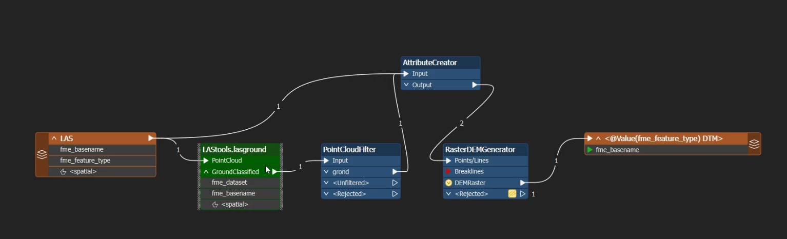
There is an old forum post where Takashi tell’s someone to expose the FME_feauture_type, fill it with the FME_basename, use a group by (using the FME_feauture_type) in the rasterdemgenerator and than use it as the raster file name.  

It doesn’t work for me…


Any other suggestions? I’m on FME 2025.0


fme_feature_type is already an attribute, you can't create an attribute with the same name.

What happens when you remove the AtributeCreator?


It doesn’t work when I remove it. I also tried the attribute manager where I change the value of the already existing attribute FME_feature_type. It also doesn’t work. 


You say it doesn't work for you. Do you get an error message? What does this message say?


the file name is .tif (so no name) or it’s rasterdemgenerator.tif… 

Where it should be something like 195000_174000.tif


The RasterDEMGenerator creates an attribute fme_basename with value 'RasterDEMGenerator’ (as is explained at the end of the old forum post you found.

I think the relevant tip is:

A possible workaround is to expose "fme_feature_type" in the LAS reader, and set it to the Group By parameter in the RasterDEMGenerator. 


so exactly what I wrote in my first post and isn’t working for me…


Well no, you wrote about exposing the FME_feauture_type, filling it with the FME_basename, and using the result of that to group by. That is not the same.


yes because after the lastools transformer I loose my fme_basename. If I inspect it, it says fme_basename: missing


So I expose the FME feature type, fill it with the fme basename before the lastools transformer and try to carry it through that way


When I try this: 


It works, but it’s not a DTM anymore as he also uses the unfiltered point cloud. I tried the geometryremover, but that doesn’t work. I get errors that way.


So I expose the FME feature type, fill it with the fme basename

To me this still sounds like a very strange thing to do.

What happens when you create a new attribute, and give it the value of fme_basename? Use that same attribute for GroupBy in the RasterDEMGenerator.


Ok, that works. I swear it was the first thing I tried… Very strange, maybe the cache clearing helped… 

On we go, now I have to try to run it with the workspacerunner. My first time so that will be interesting.

Many thx for the support!


Glad we found a solution. Good luck with your project!