Question

Filter coordinate system to reproject

  • June 14, 2018
  • 1 reply
  • 5 views

hoa_le
Contributor
Forum|alt.badge.img+5

Hi,

I have a folder which including multiple files vectors. They have different coordinate system.

Example: road.tab (EPGS: 4326), water.tab (EPSG: 32648)

I want to make a process converting coordinate look like here:

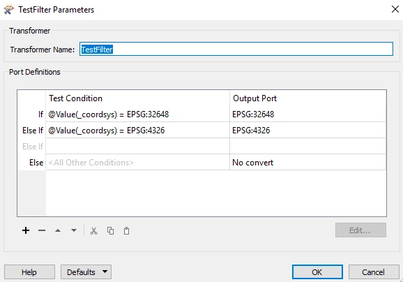
Could you show me how to make filter to reproject?

This post is closed to further activity.
It may be an old question, an answered question, an implemented idea, or a notification-only post.
Please check post dates before relying on any information in a question or answer.
For follow-up or related questions, please post a new question or idea.
If there is a genuine update to be made, please contact us and request that the post is reopened.

1 reply

takashi
Celebrity
  • 7843 replies
  • June 14, 2018
I think suitable/applicable approach could be different depending on what your purpose is. Which one is your goal?


  1. Reproject every feature into an identical coordinate system (say <CS_A>) regardless of what the original coordinate system was (e.g. EPSG:32648, EPSG:4326, etc. -> <CS_A>).
  2. Reproject features into different coordinate systems (say <CS_A>, <CS_B>, etc.) depending on the original coordinate system (e.g. EPSG:32648 -> <CS_A>, EPSG:4326 -> <CS_B>, etc.).
  3. Other.