Question

Distance down road

  • May 17, 2016
  • 4 replies
  • 149 views

Forum|alt.badge.img

Hi, I am trying to create a service area of 2km down a road network from a known starting point. Ie select any road/or part of road within 2km of my starting point (via the road (not an isochrone)). The equivalent of ArcGIS service area. I have read and downloaded the FME "Calculate Emergency Travel Times" example but am a bit lost. Im guessing i need to use the Network Cost Calculator... Any suggestions or ways forward would be appreciated. Thanks Goatboy.

This post is closed to further activity.
It may be an old question, an answered question, an implemented idea, or a notification-only post.
Please check post dates before relying on any information in a question or answer.
For follow-up or related questions, please post a new question or idea.
If there is a genuine update to be made, please contact us and request that the post is reopened.

4 replies

takashi
Celebrity
  • 7843 replies
  • May 18, 2016

Hi @goatboy, every day :) I think you are on the right track.

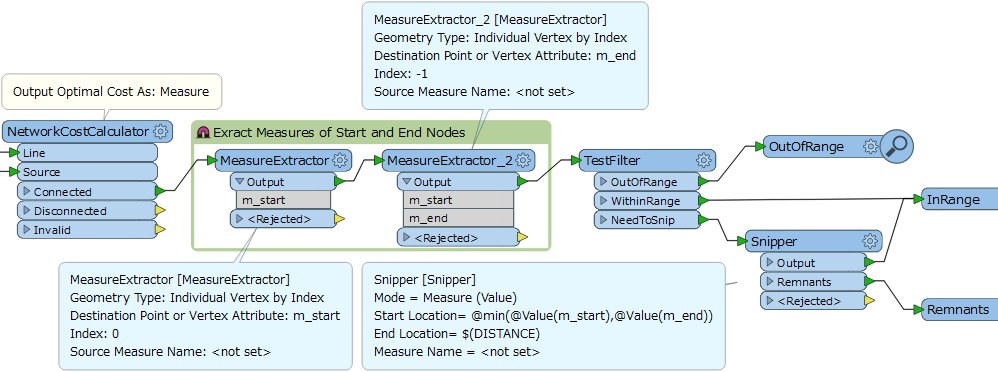
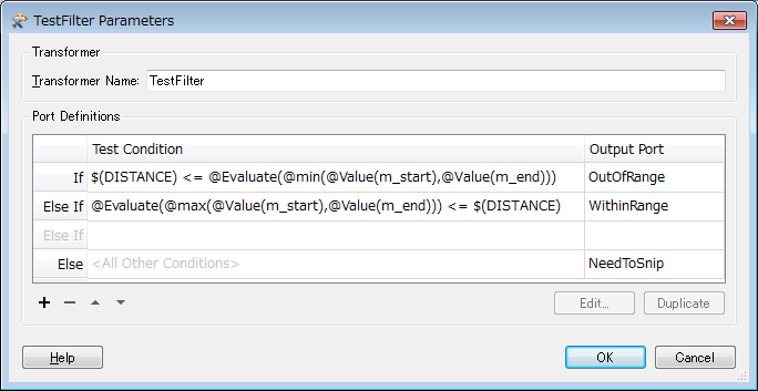
After calculating network cost with the NetworkCostCalculator (Output Optimal Cost As: Measure), extract measure values of the start and end nodes of each line. e.g. "m_start" and "m_end". You can then filter the lines like this.

  • [1] 2km <= min(m_start, m_end) --> the line is out of range --> discard
  • [2] 2km >= max(m_start, m_end) --> the line is within the range entirely.
  • [3] otherwise, the line should be snipped --> Snipper (Mode: Measure (Value))

See this screenshot.


Forum|alt.badge.img
  • Author
  • 49 replies
  • May 18, 2016

Hi @goatboy, every day :) I think you are on the right track.

After calculating network cost with the NetworkCostCalculator (Output Optimal Cost As: Measure), extract measure values of the start and end nodes of each line. e.g. "m_start" and "m_end". You can then filter the lines like this.

  • [1] 2km <= min(m_start, m_end) --> the line is out of range --> discard
  • [2] 2km >= max(m_start, m_end) --> the line is within the range entirely.
  • [3] otherwise, the line should be snipped --> Snipper (Mode: Measure (Value))

See this screenshot.

Man your good! :-) . Yes that works perfectly. Your a star, and apparently never sleep!I had better start directing some of my salary into your bank account......

The TestFilter and Snipper are really doing all the work. I would have struggled to get those test conditions myself.

Thanks Again,

ps, I promise no more questions this week !!

Steve


fme4ever
Forum|alt.badge.img
  • 10 replies
  • April 12, 2017

Hi @goatboy, every day :) I think you are on the right track.

After calculating network cost with the NetworkCostCalculator (Output Optimal Cost As: Measure), extract measure values of the start and end nodes of each line. e.g. "m_start" and "m_end". You can then filter the lines like this.

  • [1] 2km <= min(m_start, m_end) --> the line is out of range --> discard
  • [2] 2km >= max(m_start, m_end) --> the line is within the range entirely.
  • [3] otherwise, the line should be snipped --> Snipper (Mode: Measure (Value))

See this screenshot.

Takashi, you are a genius, thanks for sharing your knowledge!!


nicholas
Contributor
Forum|alt.badge.img+14
  • Contributor
  • 116 replies
  • June 26, 2020

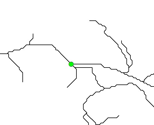
Hi @takashi just letting you know that this helped me out with my own question. I too wanted to generate streets radiating out from a point for a driven distance