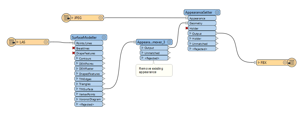
Hi there, I am trying to create a 3D photo mesh using LiDAR and aerial imagery, but find using the TIN Surface produces a more jagged output, even with a higher tolerance. I was wondering if it’s possible to do this using a DEM and if this would produce a neater result. I am using Surface Modeller to convert the LIDAR to TIN Surface. I then remove existing appearance and hook up the result along with the aerial image to the appearance setter transformer.

What should I be using to get a neater output or is TIN the only way to go?
Regards,


Josh

If you have a DSM rather than a DEM the you might want to take a look at the PointCloudSurfaceBuilder - You should be able to apply your appearance to the PointCloud using the PointCloudOnRasterComponentSetter. 

Once you have your coloured point cloud then you can feed it into the PointCloudSurfaceBuilder to try and get a mesh. 


The TINGenerator/SurfaceModeller is a good option for DEM’s - The issue with using rasters as input, however, is that depending on the resolution the output can look a bit more ‘pixelated’. Having breaklines can give a much nicer result with cleaner breaks. But in general if the Point Cloud is a bit noisy FME will not try and smooth the result. 

As far as I understand it The TINGenerator will essentially include points unless they do not change the elevation by less than the tolerance. So if you have noisy data then FME will pick up on the noise. 

If you’re able to apply some kind of smoothing to the data first that might help.  


Thanks for your detailed reply. I will try the DSM option you suggested and see how that goes.

Regards,

Josh


Reply