Question

create Smallworld 4.1.1 map projection for FME Desktop


antheatung
Contributor
Forum|alt.badge.img+4

Hello,

Original Smallworld map projection definition:


Test 1:

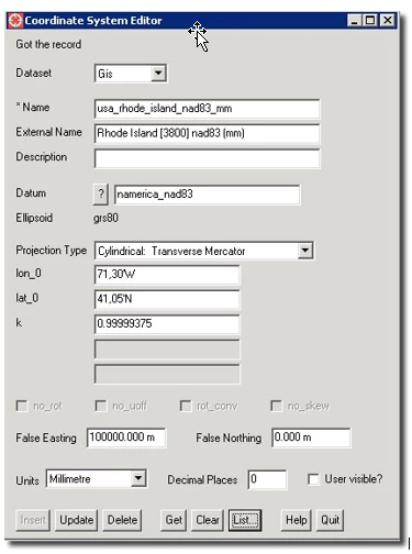
COORDINATE_SYSTEM_DEF Rhode_Island_MA_stateplane_nad83_mm \\

DESC_NM"Rhode Island stateplane MA (3800) nad83, (mm)" \\

PROJ TM \\

UNIT MILLIMETER \\

DT_NAME NAD83 \\

SCL_RED 0.99999375 \\

ORG_LAT 41.083333333333336 \\

PARM1 -71.5 \\

X_OFF 1000000000.00 \\

Y_OFF 0.000


Test 1 Result:


Test 2:


COORDINATE_SYSTEM_DEF RI83cm \\

DESC_NM "NAD83 Rhode Island State Planes, US cm" \\

DT_NAME NAD83 \\

MAP_SCL 1 \\

ORG_LAT 41.083333333333336 \\

PARM1 -71.5 \\

PROJ TM \\

QUAD 1 \\

SCL_RED 0.99999375 \\

UNIT CENTIMETER\\

X_OFF 1000000000.00 \\

Y_OFF 0.000


Test 2 Result:


5 replies

antheatung
Contributor
Forum|alt.badge.img+4
  • Author
  • Contributor
  • March 26, 2019

Hello, sorry first time posting in this forum.

Can someone please help with defining custom map projection in FME for Smallworld 4.1.1 datasets? FME 2012 Workbench is recognizing it as unknown map projection.


We tried a few tests and the two tests results (above) which did not land in space or in the ocean, seemed to be on the right path.

The native Smallworld map projection is in MILLIMETERS and in State Plane Nad 83.


Thank you in advance.

Anthea


palhermans
Contributor
Forum|alt.badge.img+10
  • Contributor
  • March 26, 2019

pratap
Contributor
Forum|alt.badge.img+12
  • Contributor
  • March 27, 2019

Use scaler with conversion factors like mm to cm or mm to meters based on projection units you have and required and later use Reprojector/EsriReprojector to required projection.

Hope this helps


palhermans
Contributor
Forum|alt.badge.img+10
  • Contributor
  • March 27, 2019
palhermans wrote:

Please apologize my ignorance, I was not aware that there might be some tricks related to SmallWorld and reference systems. Maybe the CoordinateSystemExtractor transformer could be helpful.


antheatung
Contributor
Forum|alt.badge.img+4
  • Author
  • Contributor
  • March 27, 2019

@pratap Thanks for your reply - we exported prj.4 file out of smallworld and using the CoordinateSystemDescriptioConvertor transformer - it did not recognize the projection coord sys

@palhermans thanks for the tip! This kind of pointed us to the right path...

It turns out that the coordinate system shown above is from a Smallworld "view" (local) coord sys and NOT the global coord sys that is stored in the data. We then extracted the application coordinate system (turns out to be Lambert Conic, Nad83 Millimeters). Then looked up the equivalent map projection in FME projections list and then modify the False Easting and False Northing to be in Millimeter (from Meter) and put in a custom projection definition file.

lesson learnt: make sure to use the global coord sys when dealing with Smallworld

I normally work with ESRI data and new to Smallworld.

Best,

Anthea


Reply


Cookie policy

We use cookies to enhance and personalize your experience. If you accept you agree to our full cookie policy. Learn more about our cookies.

 
Cookie settings