Question

Create column with coordinate in decimal degree

  • June 13, 2016
  • 12 replies
  • 83 views

Forum|alt.badge.img

Hello Dear FME users,

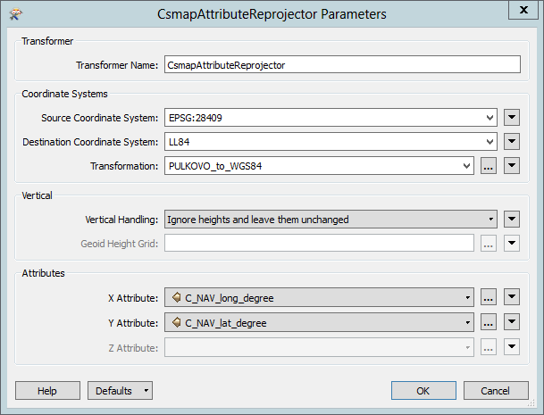
I have *.txt file. Inside this file I have columns with coordinate in metres (EPSG 28409). I need create columns with coordinate in decimal degree.

How I can realise it FME?

Thanks in advanse,

regards,

Anzhelika

This post is closed to further activity.
It may be an old question, an answered question, an implemented idea, or a notification-only post.
Please check post dates before relying on any information in a question or answer.
For follow-up or related questions, please post a new question or idea.
If there is a genuine update to be made, please contact us and request that the post is reopened.

12 replies

david_r
Celebrity
  • June 13, 2016

Look at the CsmapAttributeReprojector.

You'll probably want to select "PULKOVO_to_WGS84" in the Transformation option.


amolparande
Forum|alt.badge.img+1

you can use AttributeReprojector

,

you can use AttributeReprojector as well


david_r
Celebrity
  • June 14, 2016

you can use AttributeReprojector

,

you can use AttributeReprojector as well

That's true, but the AttributeReprojector is missing the option to explicitely set the geographic transformation, which is necessary for some reprojections if you want to preserve accuray.

It's the same thing as with the Reprojector vs the CsMapReprojector.


Forum|alt.badge.img
  • Author
  • June 15, 2016

@david_r, @amolparande Thanks a lot for your replay and aswers,

As I understand this transformers can project data, but I need to create new colums with new coordinates. in attached file you can see example of *.txt data and FME workspace, in txt I have columns C-Nav Easting, C-Nav Northing and I need output data with columns C-Nav Latitude, C-Nav Longititude with coordinates in decimal degree.

Could you please check my data and give your advise?


david_r
Celebrity
  • June 15, 2016

@david_r, @amolparande Thanks a lot for your replay and aswers,

As I understand this transformers can project data, but I need to create new colums with new coordinates. in attached file you can see example of *.txt data and FME workspace, in txt I have columns C-Nav Easting, C-Nav Northing and I need output data with columns C-Nav Latitude, C-Nav Longititude with coordinates in decimal degree.

Could you please check my data and give your advise?

I can't see any attachments, but it's really simple: Just use an AttributeCreator to copy the Easting/Northing values to a couple of new attributes containing the Latitude/Longitude values and then reproject those.


Forum|alt.badge.img
  • Author
  • June 15, 2016

david_r
Celebrity
  • June 15, 2016

Thanks for the workspace. Try replacing the AttributeReprojector with a CsmapAttributeReprojector and configure it something like this:

Hope this helps.


Forum|alt.badge.img
  • Author
  • June 15, 2016

@david_r I can't open this image or attachment. Could you please sent it for a.kamza@geoken.com


david_r
Celebrity
  • June 15, 2016

@david_r I can't open this image or attachment. Could you please sent it for a.kamza@geoken.com

I haven't posted any attachments. Does the image not show in your browser?

I'm not sure what more you need.


Forum|alt.badge.img
  • Author
  • June 15, 2016

I haven't posted any attachments. Does the image not show in your browser?

I'm not sure what more you need.

My broweser can't open it.


david_r
Celebrity
  • June 15, 2016

My broweser can't open it.

Can you see it now?


Forum|alt.badge.img
  • Author
  • June 16, 2016

thanks. Will check