Hye,
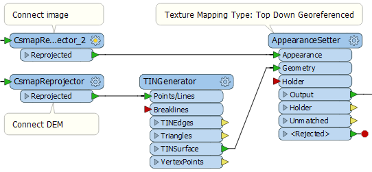
I'm trying to create a 3D terrain model (export format : .obj/.fbx/.3ds or any other textured mesh format) from imagery raster (France, IGN) and elevation raster (France, IGN).
Inputs formats are :
1. For imagery
Multiple *.jp2 files with *.tab files associated (same file name)
A sample of .tab file :
!table
!version 300
!charset WindowsLatin1
Definition Table
File "01-2015-0830-6540-LA93-5M00-E100.jp2"
Type "RASTER"
(830000.00,6540000.00) (0,0) Label "Pt 1",
(840000.00,6540000.00) (2000,0) Label "Pt 2",
(840000.00,6530000.00) (2000,2000) Label "Pt 3",
(830000.00,6530000.00) (0,2000) Label "Pt 4"
CoordSys Earth Projection 2003, 33, 7, 3, 46.5, 44, 49.00000000001, 700000, 6600000, -792421, 5278231, 3520778, 9741029
Units "m"
2. For elevation
Multiple *.asc files with *.asc.aux.xml files associated (same file name)
An extract of *.asc file :
ncols        1000
nrows        1000
xllcorner    74962.500000000000
yllcorner    6750037.500000000000
cellsize     75.000000000000
NODATA_value  -99999.00
 -99999.00 -99999.00 -99999.00 -99999.00 -99999.00 -99999.00 -99999.00 -99999.00 -99999.00 -99999.00 -99999.00 -99999.00 -99999.00 -99999.00 -99999.00 -99999.00 -99999.00 -9999[...]
An extract of *.asc.aux.xml file :
<PAMDataset>
  <SRS>COMPD_CS["RGF93 / Lambert-93 + NGF-IGN69 height",PROJCS["RGF93 / Lambert-93",GEOGCS["RGF93",DATUM["Reseau_Geodesique_Francais_1993",SPHEROID["GRS 1980",6378137,298.257222101,AUTHORITY["EPSG","7019"]],TOWGS84[0,0,0,0,0,0,0],AUTHORITY["EPSG","6171"]],PRIMEM["Greenwich",0,AUTHORITY["EPSG","8901"]],UNIT["degree",0.0174532925199433,AUTHORITY["EPSG","9122"]],AUTHORITY["EPSG","4171"]],PROJECTION["Lambert_Conformal_Conic_2SP"],PARAMETER["standard_parallel_1",49],PARAMETER["standard_parallel_2",44],PARAMETER["latitude_of_origin",46.5],PARAMETER["central_meridian",3],PARAMETER["false_easting",700000],PARAMETER["false_northing",6600000],UNIT["metre",1,AUTHORITY["EPSG","9001"]],AXIS["X",EAST],AXIS["Y",NORTH],AUTHORITY["EPSG","2154"]],VERT_CS["NGF-IGN69 height",VERT_DATUM["Nivellement General de la France - IGN69",2005,AUTHORITY["EPSG","5119"]],UNIT["metre",1,AUTHORITY["EPSG","9001"]],AXIS["Up",UP],AUTHORITY["EPSG","5720"]],AUTHORITY["EPSG","5698"]]</SRS>
  <PAMRasterBand band="1">
    <Metadata>
      <MDI key="STATISTICS_MAXIMUM">102.4</MDI>
      <MDI key="STATISTICS_MEAN">43.77518150174</MDI>
      <MDI key="STATISTICS_MINIMUM">-2.79</MDI>
      <MDI key="STATISTICS_STDDEV">26.137841691288</MDI>
    </Metadata>
  </PAMRasterBand>
</PAMDataset>
I'm discovering FME and I'm working with a demo licence, so I need a complete explaination of the workflow please...
And... I'm French, so... my english is very bad :/ Sorry !
,Hye,
I'm trying to create a 3D terrain model (export format : .obj/.fbx/.3ds or any other textured mesh format) from imagery raster (France, IGN) and elevation raster (France, IGN).
Inputs formats are :
1. For imagery
Multiple *.jp2 files with *.tab files associated (same file name)
A sample of .tab file :
!table
!version 300
!charset WindowsLatin1


Definition Table
File "01-2015-0830-6540-LA93-5M00-E100.jp2"
Type "RASTER"
(830000.00,6540000.00) (0,0) Label "Pt 1",
(840000.00,6540000.00) (2000,0) Label "Pt 2",
(840000.00,6530000.00) (2000,2000) Label "Pt 3",
(830000.00,6530000.00) (0,2000) Label "Pt 4"
CoordSys Earth Projection 2003, 33, 7, 3, 46.5, 44, 49.00000000001, 700000, 6600000, -792421, 5278231, 3520778, 9741029
Units "m"
2. For elevation
Multiple *.asc files with *.asc.aux.xml files associated (same file name)
An extract of *.asc file :
ncols        1000
nrows        1000
xllcorner    74962.500000000000
yllcorner    6750037.500000000000
cellsize     75.000000000000
NODATA_value  -99999.00
 -99999.00 -99999.00 -99999.00 -99999.00 -99999.00 -99999.00 -99999.00 -99999.00 -99999.00 -99999.00 -99999.00 -99999.00 -99999.00 -99999.00 -99999.00 -99999.00 -99999.00 -9999[...]
An extract of *.asc.aux.xml file :
<PAMDataset>
  <SRS>COMPD_CS["RGF93 / Lambert-93 + NGF-IGN69 height",PROJCS["RGF93 / Lambert-93",GEOGCS["RGF93",DATUM["Reseau_Geodesique_Francais_1993",SPHEROID["GRS 1980",6378137,298.257222101,AUTHORITY["EPSG","7019"]],TOWGS84[0,0,0,0,0,0,0],AUTHORITY["EPSG","6171"]],PRIMEM["Greenwich",0,AUTHORITY["EPSG","8901"]],UNIT["degree",0.0174532925199433,AUTHORITY["EPSG","9122"]],AUTHORITY["EPSG","4171"]],PROJECTION["Lambert_Conformal_Conic_2SP"],PARAMETER["standard_parallel_1",49],PARAMETER["standard_parallel_2",44],PARAMETER["latitude_of_origin",46.5],PARAMETER["central_meridian",3],PARAMETER["false_easting",700000],PARAMETER["false_northing",6600000],UNIT["metre",1,AUTHORITY["EPSG","9001"]],AXIS["X",EAST],AXIS["Y",NORTH],AUTHORITY["EPSG","2154"]],VERT_CS["NGF-IGN69 height",VERT_DATUM["Nivellement General de la France - IGN69",2005,AUTHORITY["EPSG","5119"]],UNIT["metre",1,AUTHORITY["EPSG","9001"]],AXIS["Up",UP],AUTHORITY["EPSG","5720"]],AUTHORITY["EPSG","5698"]]</SRS>
  <PAMRasterBand band="1">
    <Metadata>
      <MDI key="STATISTICS_MAXIMUM">102.4</MDI>
      <MDI key="STATISTICS_MEAN">43.77518150174</MDI>
      <MDI key="STATISTICS_MINIMUM">-2.79</MDI>
      <MDI key="STATISTICS_STDDEV">26.137841691288</MDI>
    </Metadata>
  </PAMRasterBand>
</PAMDataset>
I'm discovering FME and I'm working with a demo licence, so I need a complete explaination of the workflow please...
And... I'm French, so... my english is very bad :/ Sorry !


