Question

Clip and mosaic multiple rasters by updated administrative polygons boundaries

  • May 12, 2020
  • 2 replies
  • 75 views

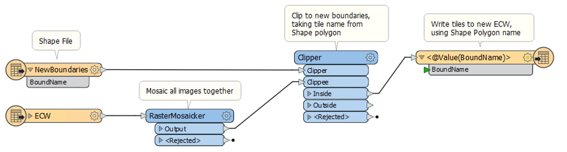
I have some big ECW files 3-6gb each and they are clipped by the administrative boundaries (50polygons,1 shape file,attribute name is administrative unit name).

Now the administrative boundaries has changed and updated and i want to use this new polygons as clipping feature where rasters should be clipped or merged(mosaic) by parts of neighbor raster based on the new boundary which they fall inside. What is the right workflow cause i dont want to do it one by one filtering the administrative units shape file one by one, i want that the rasters to be clipped inside the new boundary for every administrative unit(where all the units are inside one shapefile with the attribute as administrative unit name).

And i am not sure if the ECW files are the recommended format for this process case i'v read that they are very slow.

This post is closed to further activity.
It may be an old question, an answered question, an implemented idea, or a notification-only post.
Please check post dates before relying on any information in a question or answer.
For follow-up or related questions, please post a new question or idea.
If there is a genuine update to be made, please contact us and request that the post is reopened.

2 replies

daveatsafe
Safer
Forum|alt.badge.img+19
  • Safer
  • 1637 replies
  • May 12, 2020

Hi @shefqetlulja,

The workspace for this process is fairly simple:


FME will build a virtual mosaic for the clip, instead an actual large image, so it is safe to read all the ECW images in one reader.

However, compressing the data into the new ECW file can be a major workload on your processor. I would recommend using a computer with quite a bit of RAM for this process.

Alternatively, you could use a Tester to do only one boundary at a time. FME's raster optimization will ensure that only the ECW sources covering the single output ECW will actually be read.


  • Author
  • 18 replies
  • May 13, 2020

Hi @shefqetlulja,

The workspace for this process is fairly simple:


FME will build a virtual mosaic for the clip, instead an actual large image, so it is safe to read all the ECW images in one reader.

However, compressing the data into the new ECW file can be a major workload on your processor. I would recommend using a computer with quite a bit of RAM for this process.

Alternatively, you could use a Tester to do only one boundary at a time. FME's raster optimization will ensure that only the ECW sources covering the single output ECW will actually be read.

Does this clip the rasters grouped by bound name? because i dont want to clip those as a big dissolved clipper but i want to be clipped for every unit based on the boundname.

For example: if the shape file has 5 polygon units i want to be exported 5 rasters ECW in the same time not putting a tester and to filter one by one the polygon units.