I have Parcel data and crop data (polygon geom). I am trying to calculate the crop type ratio for each parcel.
My plan was:
Clip the crop data based on parcel
Calculate statistics based on crop type and group by ParcelID
I am not getting a sufficient result.
Any help is appreciated. The workbench has been attached.
Best answer by markatsafe
@canerakin111 Thanks for including the sample data. You can bundle a workspace and data using the File -> Save As Template : makes it easy to ship small examples.
I think the AreaOnAreaOverlayer and the Aggregator are the two key transformers you can use here. I've attached a small example that you can expand on: croptype-per-parcel V1.fmwt
This post is closed to further activity.
It may be an old question, an answered question, an implemented idea, or a notification-only post.
Please check post dates before relying on any information in a question or answer.
For follow-up or related questions, please post a new question or idea.
If there is a genuine update to be made, please contact us and request that the post is reopened.
I just published a sample data under Mark's comment. I hope this can help to describe the issue better.
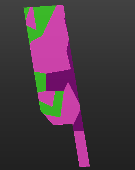
What output are you looking to get? It's not clear what statistics you are looking for - number of different crop types? Number of discrete crop types? Total area of each crop type per parcel? Crop type with the greatest area in the parcel? Largest discrete area in the parcel?
e.g. the below parcel has 3 different crop types, but 12 discrete areas of crop
I am trying to calculate two things:
1. Each parcel have multiple crop types. I am trying to calculate the percentage of crop types for each parcel. For example, PRCL000001 has Broadleaf, vineyard and shrubland. What is the ratio of them in this parcel based on the area? The output should be something like 35% Broadleaf, 60% vineyard, 5% shrubland.
2. What is the crop type with the greatest area in the parcel? In the example above, it will be a vineyard, so I will assign this parcel vineyard.
@canerakin111 Thanks for including the sample data. You can bundle a workspace and data using the File -> Save As Template : makes it easy to ship small examples.
I think the AreaOnAreaOverlayer and the Aggregator are the two key transformers you can use here. I've attached a small example that you can expand on: croptype-per-parcel V1.fmwt