Hi all,


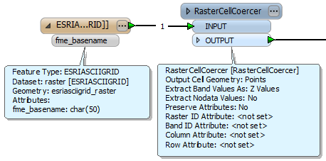
I'm a complete novice at using this technology, but I am trying to convert some ASCII files (that appear as greyscale rasters) into a file that shows a point for each cell with a z value.  Is this possible?


Apologies if it is a really basic question!!
There was a similar question here http://fmepedia.safe.com/AnswersQuestionDetail?id=906a0000000ci7MAAQ and the reply will be similar. Have a look at the file in a text editor, assuming thats possible you should be able to see the X Y and Z values. Depending on how it's delimited you'll be able to use either the Text reader or the CSV reader. Then use a 3DPointReplacer to create a point with a Z axis. If the format is a common LIDAR format then take a look at some of the dedicated LiDAR format readers and transformers.


Good luck.
Thanks Dave, and sorry I didn't spot the other answer! Just as the person posting that request; my data (when viewed in text file) is X,Y,Z,Z,Z etc. as shown below:


ncols         200


nrows         200


xllcorner     387000.000


yllcorner     280000.000


cellsize      5


nodata_value  -9999.0


95.298 95.178 95.061 94.962 94.918 94.97 95.096 95.236 95.337 95.405 95.531 95.839 96.364 96.995 97.607 98.153 98.622 99.038 99.412 99.777 100.113 100.399 100.627 100.778 100.859 100.884 100.874 100.838 100.782 100.72 100.652 100.61 100.619 100.652 100.668 100.67 100.68


So the way you describe in that answer is the simplest way to do it?
Hi,


this looks like an ESRI ASCII Grid. You can transform it to vector points (one point per grid cell) using a RasterCellCoercer. Specify "Extract band values as: Z-values".


David
It might be but you may want to try out the ASCII readers in FME first to see if they manage to parse the stucture successfully for you. The one I have had a bit of success with is the ESRI ASCII Reader.
This seemed to work very well with the small sample grid posted above:


Tested using FME2013 SP1.


David

Reply