Question

ArcGISAttachmentConnector error: The page was not displayed because the request entity is too large.

  • October 19, 2025
  • 13 replies
  • 145 views

brandonguo
Contributor
Forum|alt.badge.img+4

I got this error when trying to add attachments to AGO: The ArcGIS REST API returned an error: HTTP Error Code: 413 : '' Message Code . Further details: 'The page was not displayed because the request entity is too large.'

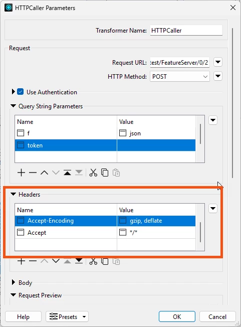
Esri community has a solution to edit the header, but there’s no option to edit header on transformer?


13 replies

j.botterill
Influencer
Forum|alt.badge.img+53
  • Influencer
  • October 20, 2025

desiree_at_safe
Safer
Forum|alt.badge.img+16


Hi ​@brandonguo!

I haven't run into this issue with the ArcGISAttachmentConnector before, but the 413 error and workaround you mentioned (editing headers) is interesting and could point to a potential improvement or fix we need to make, as ​@j.botterill mentioned.

To help us dig into this further, would you be willing to share:

  • A log file with log debug on (which gives us information about your FME version and translation process)
  • A sample workspace, screenshots, or simply file that causes this issue

This should give us a clearer picture of the best approach going forward 🙂Alternatively, you can also submit a support case with us if you rather not share your process here: 


brandonguo
Contributor
Forum|alt.badge.img+4
  • Author
  • Contributor
  • October 30, 2025

Hi ​@desiree_at_safe 

See the workbench screenshot below, and part of the log file, hopefully it’s helpful.


2025-10-27 14:31:32|  36.3|  0.0|WARN  |DEBUG: urllib3.connectionpool https://services-ap1.arcgis.com:443 "POST /***********/arcgis/rest/services/PlansDrawings_***********/FeatureServer/0/584/addAttachment?f=json&token=***********-*********** HTTP/1.1" 413 67

2025-10-27 14:31:32|  36.3|  0.0|WARN  |Connection Storage: Current time: 1761535892, Expiry time: 1761537321

2025-10-27 14:31:32|  36.3|  0.0|WARN  |DEBUG: http.client send: b'POST /***********/arcgis/rest/services/PlansDrawings_***********/FeatureServer/0/618/addAttachment?f=json&token=***********-***********- HTTP/1.1\r\nHost: services-ap1.arcgis.com\r\nUser-Agent: FME/2024.7.51.24801 python-requests/2.32.3\r\nAccept-Encoding: gzip, deflate\r\nAccept: */*\r\nConnection: keep-alive\r\nContent-Length: 22958965\r\nContent-Type: multipart/form-data; boundary=7da8558c2e3d576c285146589400030c\r\nAuthorization: Bearer ***********-NIvJEb-***********\r\n\r\n'

2025-10-27 14:31:33|  36.5|  0.2|WARN  |DEBUG: http.client send: b'--7da8558c2e3d576c285146589400030c\r\nContent-Disposition: form-data; name="f"\r\n\r\njson\r\n--7da8558c2e3d576c285146589400030c\r\nContent-Disposition: form-data; name="attachment"; filename="***.pdf"\r\nContent-Type: application/pdf\r\n\r\n%PDF-1.7\********************

2025-10-27 14:31:34|  36.6|  0.1|WARN  |DEBUG: http.client reply: 'HTTP/1.1 413 Request Entity Too Large\r\n'

2025-10-27 14:31:34|  36.6|  0.0|WARN  |DEBUG: http.client header: Date: Mon, 27 Oct 2025 03:31:34 GMT

2025-10-27 14:31:34|  36.6|  0.0|WARN  |DEBUG: http.client header: Content-Type: text/html

2025-10-27 14:31:34|  36.6|  0.0|WARN  |DEBUG: http.client header: Content-Length: 67

2025-10-27 14:31:34|  36.6|  0.0|WARN  |DEBUG: http.client header: Connection: keep-alive

2025-10-27 14:31:34|  36.6|  0.0|WARN  |DEBUG: http.client header: Vary: X-Esri-Authorization

2025-10-27 14:31:34|  36.6|  0.0|WARN  |DEBUG: http.client header: Request-Context: appId=cid-v1:1bba6b68-99a2-4fc8-af9d-affe0c423ee5

2025-10-27 14:31:34|  36.6|  0.0|WARN  |DEBUG: http.client header: x-arcgis-upstream: ap1h00c00

2025-10-27 14:31:34|  36.6|  0.0|WARN  |DEBUG: http.client header: Strict-Transport-Security: max-age=63072000

2025-10-27 14:31:34|  36.7|  0.1|WARN  |DEBUG: http.client header: X-ArcGIS-Correlation-Id: 238dc17fc59ccea3

2025-10-27 14:31:34|  36.7|  0.0|WARN  |DEBUG: http.client header: X-ArcGIS-Instance: ***********

2025-10-27 14:31:34|  36.7|  0.0|WARN  |DEBUG: http.client header: Access-Control-Allow-Origin: *

2025-10-27 14:31:34|  36.7|  0.0|WARN  |DEBUG: http.client header: Access-Control-Allow-Headers: Content-Type, Authorization, X-Esri-Authorization

2025-10-27 14:31:34|  36.7|  0.0|WARN  |DEBUG: http.client header: Access-Control-Allow-Credentials: true

2025-10-27 14:31:34|  36.7|  0.0|WARN  |DEBUG: http.client header: x-azure-ref: ***********-r1b5d8b8bc6vj569hC1MELpv1c00000005z0000000005231

2025-10-27 14:31:34|  36.7|  0.0|WARN  |DEBUG: http.client header: X-Cache: CONFIG_NOCACHE


salvaleonrp
Enthusiast
Forum|alt.badge.img+20
  • Enthusiast
  • October 31, 2025

Note that there is a 2GB limit through a multi-part upload using the REST API which is what the  AddAttachmentConnector uses. Do you know the file sizes of your attachments?

https://support.esri.com/en-us/knowledge-base/how-to-add-large-attachments-to-a-feature-using-the-arc-000029873


desiree_at_safe
Safer
Forum|alt.badge.img+16

Hi ​@brandonguo!

I was able to reproduce your issue with a 29.3 MB PDF. It seems large images can trigger a similar error, though it’s not exactly the same one.

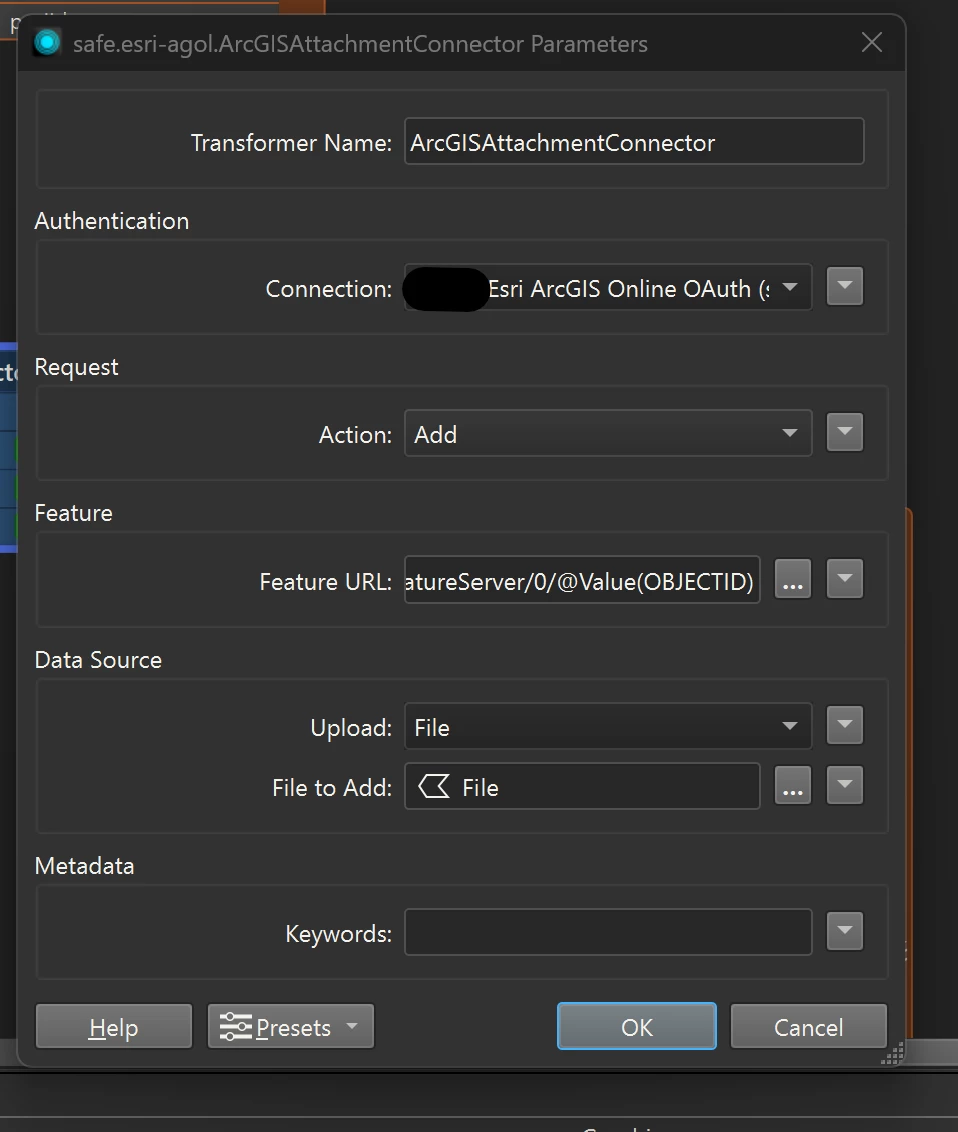
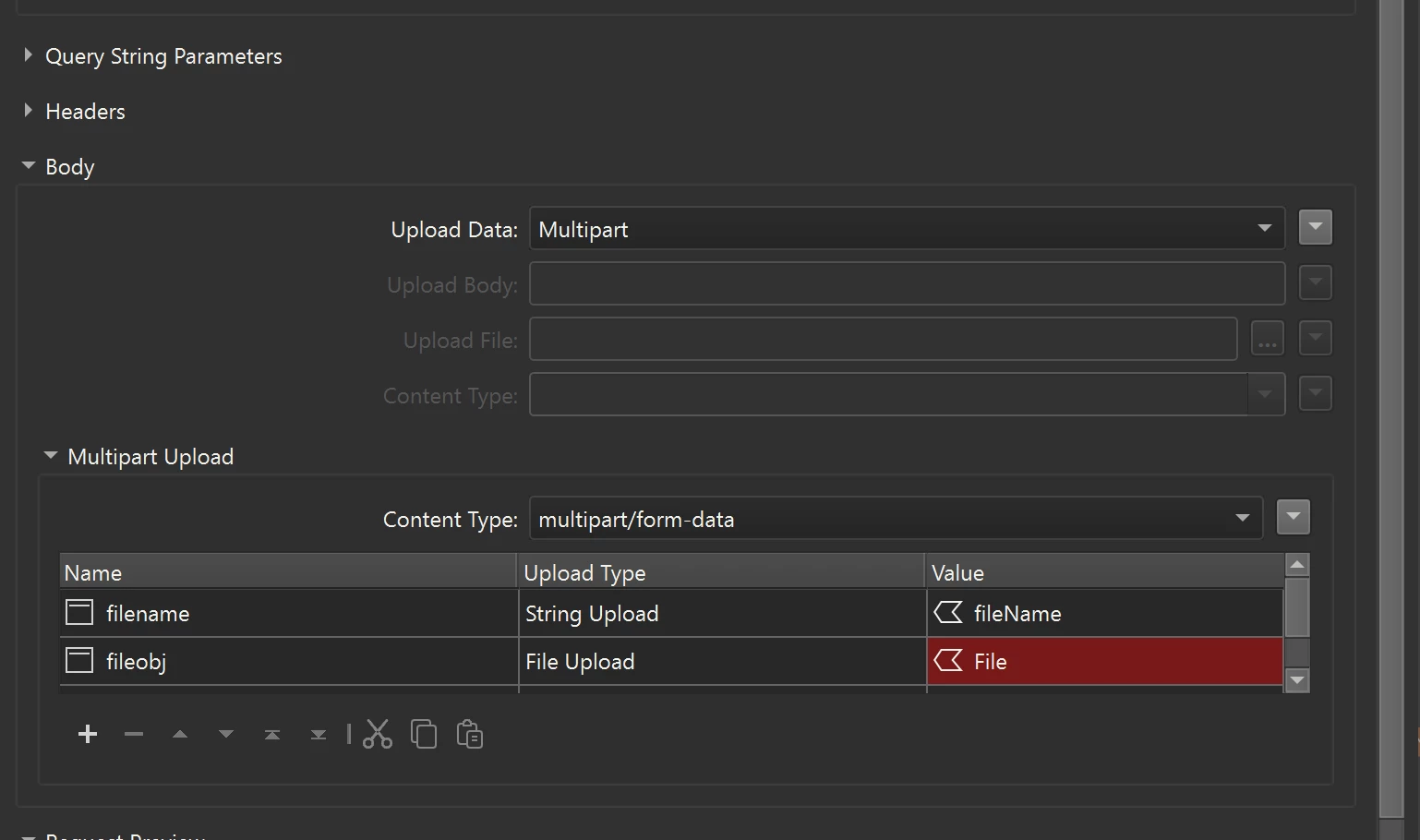
Regarding the workaround, while I haven’t tested the “edit header” method you mentioned (which I believe was discussed in an Esri Community thread), you could theoretically construct the REST API call in the HTTPCaller and edit or specify that header there: 

Could you share the exact thread you’re referring to so I can confirm?

It also looks like there are a few other potential workarounds mentioned in this Esri Documentation on how to Attach files larger than 10 MB , such as compressing the file or uploading it to ArcGIS Online and attaching a link instead.

Either way, it does look like this is a great candidate for product improvement IDEA. I’d encourage you to Submit an Idea Here. Other FME Community users can upvote it, and our product team reviews these for future inclusion in FME. 🙂


desiree_at_safe
Safer
Forum|alt.badge.img+16

Thank you for sharing that doc ​@salvaleonrp! It’s possible we might be using an older version of this REST API

I’ve created a case for the team to investigate this further! 

[INTERNAL REF: FMEENGINE-88567]


mgg_beca
Supporter
Forum|alt.badge.img+16
  • Supporter
  • November 9, 2025

Hi,

I have struck the same error. In my case I cannot upload any pdf files larger than 10mb, so I wonder if the multi-part uploading is not working correctly.


brandonguo
Contributor
Forum|alt.badge.img+4
  • Author
  • Contributor
  • November 9, 2025

brandonguo
Contributor
Forum|alt.badge.img+4
  • Author
  • Contributor
  • November 9, 2025

@mgg_beca Try using httpcaller, it solved most of the file upload issues with ArcGISAttachmentConnector. Though I still have few failed uploads left. 


mgg_beca
Supporter
Forum|alt.badge.img+16
  • Supporter
  • November 9, 2025

@mgg_beca Try using httpcaller, it solved most of the file upload issues with ArcGISAttachmentConnector. Though I still have few failed uploads left. 

Hi Brandon,

I am still get ting the same error with httpcaller, did you have to add any additional headers or workarounds?

This is not working for me


brandonguo
Contributor
Forum|alt.badge.img+4
  • Author
  • Contributor
  • November 9, 2025

@mgg_beca 

My setup, this solved half of the failed attachments by ArcGISAttachmentConnector. Still, not perfect solution. 


mgg_beca
Supporter
Forum|alt.badge.img+16
  • Supporter
  • November 10, 2025

 I ended up just using an output from fme as a match table and doing it in ArcGIS Pro. worked fine.


salvaleonrp
Enthusiast
Forum|alt.badge.img+20
  • Enthusiast
  • November 10, 2025

I wonder if you hae the right mime-type for a PDF file.


Check this out:


@mgg_beca the mime-type for a pdf is: application/pdf. This is not in the drop down but you can type it.