Question

Anchored snapper - problem snapping polygons to lines

  • August 16, 2018
  • 3 replies
  • 53 views

eric_armitage
Contributor
Forum|alt.badge.img+10

Hi

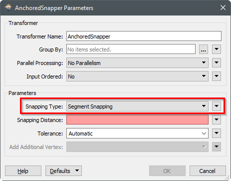
I'm trying to use the anchored snapper to snap polygon boundaries to cadastral lines. However, it only seems to snap the vertices of the canditates and doesn't create extra vertices in between to make the polygon boundary align to the cadastral. Is there a way to force it to create additional vertices where necessary?

This post is closed to further activity.
It may be an old question, an answered question, an implemented idea, or a notification-only post.
Please check post dates before relying on any information in a question or answer.
For follow-up or related questions, please post a new question or idea.
If there is a genuine update to be made, please contact us and request that the post is reopened.

3 replies

davideagle
Contributor
Forum|alt.badge.img+22
  • Contributor
  • 578 replies
  • August 16, 2018

In cases like this it may be worth considering passing your data to snap through a Densifier transformer ahead of the Snap to make it more likely to produce a good result.


david_r
Celebrity
  • 8394 replies
  • August 16, 2018

Make sure you set snapping type to segment snapping:


eric_armitage
Contributor
Forum|alt.badge.img+10
  • Author
  • Contributor
  • 37 replies
  • August 17, 2018

Make sure you set snapping type to segment snapping:

Yes i tried that but it only seems to snap the end points of each canditate segment. It doesn't create extra vertices/ segments in the canditate to match the anchor.