Solved

Adding a map of the features in HTMLReportGenerator


ammar.shaarbaf
Contributor
Forum|alt.badge.img+3

Hi,

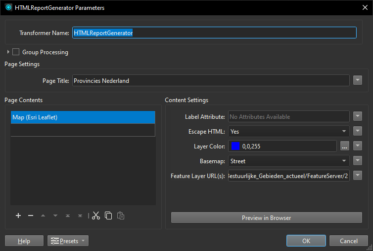
Is it possible to add a map of a feature/layer in an HTML report using the HTMLReportGenerator?


Thank you in advance

Best answer by nielsgerrits

Yes.


View original
Did this help you find an answer to your question?

5 replies

nielsgerrits
VIP
Forum|alt.badge.img+53
  • Best Answer
  • August 26, 2024

Yes.


danilo_fme
Evangelist
Forum|alt.badge.img+42
  • Evangelist
  • August 26, 2024
nielsgerrits wrote:

Yes.


Great answer.


ammar.shaarbaf
Contributor
Forum|alt.badge.img+3
nielsgerrits wrote:

Yes.


Thank you very much! :)


s.jager
Influencer
Forum|alt.badge.img+16
  • Influencer
  • August 26, 2024

From the 4 pre-configured options, the other 3 either require an access token, or very clearly state something about “for development purposes only” (so probably need an access toen as well, or something...).

If you want to have a bit more control (or, like me, simply do not want to use any of the proprietary versions...), it is not that difficult to add a Custom HTML section, and use Openlayers and a bit of Javascript. Getting the geometry from the features is easy enough using a GeometryExtractor set to GeoJson. This way you have full control over the background maps as well.

It’s the solution I chose instead of one of the 4 preconfigured ones. So something like this:

<link rel="stylesheet" href="https://openlayers.org/en/v6.15.1/css/ol.css"/>
<script src="https://openlayers.org/en/v6.15.1/build/ol.js"> </script>
<div id="map" class="map" style="border: 2px solid black; widht:500px; height:500px;"></div>
<script>
  function getBufferedExtent(olFeature)
  {
    var geom = olFeature.getGeometry();
    var ext = geom.getExtent();
    var buffer = ol.extent.buffer(ext, 50);
    return buffer;
  };
  function zoomTo(olFeature)
  {
    var zext = getBufferedExtent(olFeature);
    map.getView().fit(zext, map.getSize());
  };
  var brtachtergrond = new ol.layer.Tile({
      visible:true,
      source: new ol.source.XYZ({attributions: '&copy; <a href="https://www.pdok.nl" target="_blank">PDOK</a>',
                                 url: 'https://service.pdok.nl/brt/achtergrondkaart/wmts/v2_0/standaard/EPSG:3857/{z}/{x}/{y}.png',
                                 projection: 'EPSG:3857'
                                 })
                                });
  var perceelSource = new ol.source.Vector();
  var perceelLayer = new ol.layer.Vector({
      source: perceelSource,
      style: new ol.style.Style ({
             stroke: new ol.style.Stroke({ color: 'rgba(00, 00, 150, 1)', width: 2}),
             fill: new ol.style.Fill({ color: 'rgba(00, 00, 150, 0.25)' })
        })
    });
  var pol = @Value(_GeoJson);
  var format = new ol.format.GeoJSON();
  var perceelFeature = format.readFeature(pol);
  perceelSource.addFeature(perceelFeature);
  var scaleLineControl = new ol.control.ScaleLine();
  scaleLineControl.setUnits('metric');
  var map= new ol.Map({
    layers: [brtachtergrond,
             perceelLayer
            ],
    target: 'map',
    controls:ol.control.defaults({attributionOptions: ({collapsible: false}) }).extend([scaleLineControl]),
    view: new ol.View({ projection: 'EPSG:3857',
                        center: [650946, 5788365],
                        zoom: 5
      })
  });
  zoomTo(perceelFeature);
</script>

Note the line

var pol = @Value(_GeoJson);

_GeoJson is the attribute I used to extract the geometry to, using a GeometryExtractor, with GeoJson as Geometry Encoding.


nielsgerrits
VIP
Forum|alt.badge.img+53
danilo_fme wrote:
nielsgerrits wrote:

Yes.

Great answer.

I could think of a lot of additions, but the question was clear so is the answer 😁 but I’ll admit it is a bit sparse.  

s.jager wrote:

From the 4 pre-configured options, the other 3 either require an access token, or very clearly state something about “for development purposes only” (so probably need an access toen as well, or something...).

...

This is an answer to bookmark! Working samples are the best.


Cookie policy

We use cookies to enhance and personalize your experience. If you accept you agree to our full cookie policy. Learn more about our cookies.

 
Cookie settings