Solved

Geometry As Published Parameter - Needing help setting coordinate system!


benvk
Contributor
Forum|alt.badge.img+7
  • Contributor

Hi,

End Goal: To have my FME server have a workspace where a user can draw a polygon shape, and FME provide a ZIP file containing all watermains within that polygon shape area.


I have a workspace (attached) that reads an ArcGIS Online Feature Layer (water mains), and i am attempting to use a set of coordinates as GeoJSON to clip this selection and output the selected areas water mains.

I have been using this tutorial as a guide - https://s3.amazonaws.com/gitbook/Server-Authoring-2020/ServerAuthoring3SelfServe/Exercise3.html - but I am unsure how to get the coordinate systems to match.


I understand the two items (the user input and watermain feature layer) need to be in the same coordinate system in order for the clipper to work, and I have no idea how to achieve this with these two data sources.

I created a parameter (similar to the screenshot) with a default which is surrounding our local city:

2020-08-22 22_39_52-geojson.io


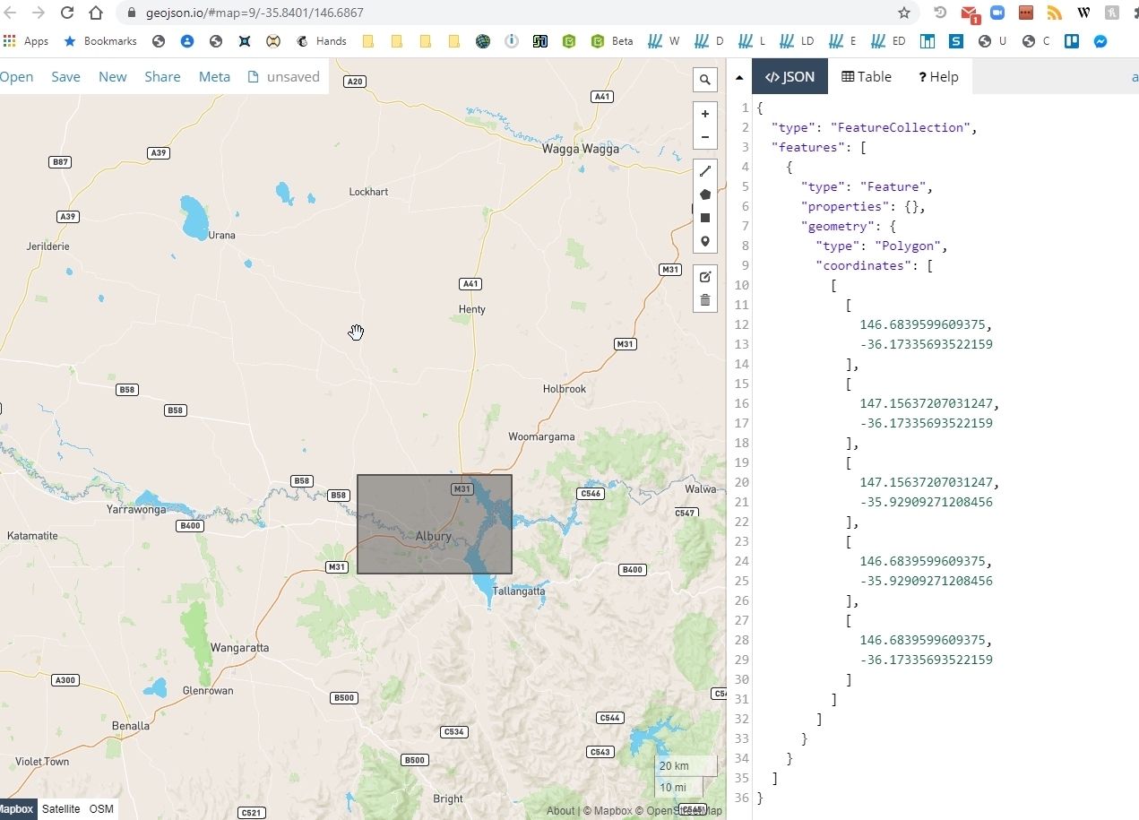
If I use the Visual Preview to inspect the 'geometry replacer', which is using my manually inputted coordinates, it is showing the correct 'shape', but is showing "coordinate system: Unknown"

2020-08-22 22_45_28-_NONE to XLSXW (C__Users_Ben_Desktop_Clip AGOL Data.fmw) - FME Workbench 2020.0


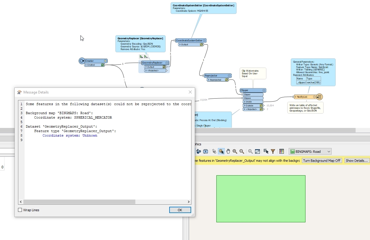
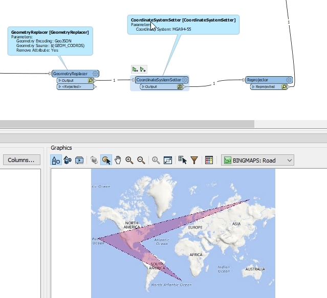
And if I try the Coordinate System Setter and Reprojector as the tutorial does, it completely screws with the clip area I am trying to use:

2020-08-22 22_47_55-_NONE to XLSXW (C__Users_Ben_Desktop_Clip AGOL Data.fmw) - FME Workbench 2020.0


I am completely lost. I was thinking this would be straight forward as the tutorial shows, but I am left scratching my head!


Thanks for your time.

Best answer by drc43

siennaatsafe wrote:

Hi @benvk​ ,


I'm pretty sure the coordinates you are setting are in EPSG:4326 https://github.com/mapbox/geojson.io/issues/640 which is the same as LL84 in FME. 2020-08-25_13-29-43

If you set that in the CoordinateSystemSetter, you should see the correct shape. 2020-08-25_13-32-13

From there you could reproject using the reprojector to MGA94-55.


However, I believe ArcGIS Online uses WGS84 for everything by default, however this information may be out of date so I'd check with with them. https://resource.esriuk.com/blog/2014-6-20-arcgis-online-brings-projections-to-our-world-html/#:~:text=ArcGIS%20Online%20uses%20the%20WGS,Geographic%20Coordinate%20System%20(GCS).


Yeah, I agree with Sienna.


Your first screen shot shows coordinates in latitude - longitude decimal degrees. Thus your CoordinateSystemSetter should be set to LL84 not MGA94. That would go in your Reprojector.

View original
Did this help you find an answer to your question?

5 replies

sigtill
Contributor
Forum|alt.badge.img+24
  • Contributor
  • August 25, 2020

Hi @benvk​ ! I see the Coordinatesystemsetter is YELLOW - so the cache might be "old". If you click "Run to this" on the Coordinatesystemsetter the workspace will run whats not cached again and you get updated data. Does the coordinatesystem work now?


If not, can you upload the GeoJSON here and the coordinate system?


benvk
Contributor
Forum|alt.badge.img+7
  • Author
  • Contributor
  • August 25, 2020
sigtill wrote:

Hi @benvk​ ! I see the Coordinatesystemsetter is YELLOW - so the cache might be "old". If you click "Run to this" on the Coordinatesystemsetter the workspace will run whats not cached again and you get updated data. Does the coordinatesystem work now?


If not, can you upload the GeoJSON here and the coordinate system?


Unfortunately this made no change :(


Just to clarify, I have drawn a rectangle in the geoJSON generator, then I can see the rectangle at the geometry replacer, but then at the next step it throws the coords around and makes a funny looking shape. So I think I am way off the mark with this one!


siennaatsafe
Safer
Forum|alt.badge.img+10

Hi @benvk​ ,


I'm pretty sure the coordinates you are setting are in EPSG:4326 https://github.com/mapbox/geojson.io/issues/640 which is the same as LL84 in FME. 2020-08-25_13-29-43

If you set that in the CoordinateSystemSetter, you should see the correct shape. 2020-08-25_13-32-13

From there you could reproject using the reprojector to MGA94-55.


However, I believe ArcGIS Online uses WGS84 for everything by default, however this information may be out of date so I'd check with with them. https://resource.esriuk.com/blog/2014-6-20-arcgis-online-brings-projections-to-our-world-html/#:~:text=ArcGIS%20Online%20uses%20the%20WGS,Geographic%20Coordinate%20System%20(GCS).


drc43
Contributor
Forum|alt.badge.img+11
  • Contributor
  • Best Answer
  • August 25, 2020
siennaatsafe wrote:

Hi @benvk​ ,


I'm pretty sure the coordinates you are setting are in EPSG:4326 https://github.com/mapbox/geojson.io/issues/640 which is the same as LL84 in FME. 2020-08-25_13-29-43

If you set that in the CoordinateSystemSetter, you should see the correct shape. 2020-08-25_13-32-13

From there you could reproject using the reprojector to MGA94-55.


However, I believe ArcGIS Online uses WGS84 for everything by default, however this information may be out of date so I'd check with with them. https://resource.esriuk.com/blog/2014-6-20-arcgis-online-brings-projections-to-our-world-html/#:~:text=ArcGIS%20Online%20uses%20the%20WGS,Geographic%20Coordinate%20System%20(GCS).


Yeah, I agree with Sienna.


Your first screen shot shows coordinates in latitude - longitude decimal degrees. Thus your CoordinateSystemSetter should be set to LL84 not MGA94. That would go in your Reprojector.


benvk
Contributor
Forum|alt.badge.img+7
  • Author
  • Contributor
  • August 28, 2020
drc43 wrote:

Yeah, I agree with Sienna.


Your first screen shot shows coordinates in latitude - longitude decimal degrees. Thus your CoordinateSystemSetter should be set to LL84 not MGA94. That would go in your Reprojector.

thank so much, spot on what I needed to fix my mistake.


Thanks again


Reply


Cookie policy

We use cookies to enhance and personalize your experience. If you accept you agree to our full cookie policy. Learn more about our cookies.

 
Cookie settings