Solved

FME Desktop won't load data from this WFS service.

  • February 26, 2016
  • 4 replies
  • 35 views

Forum|alt.badge.img+4

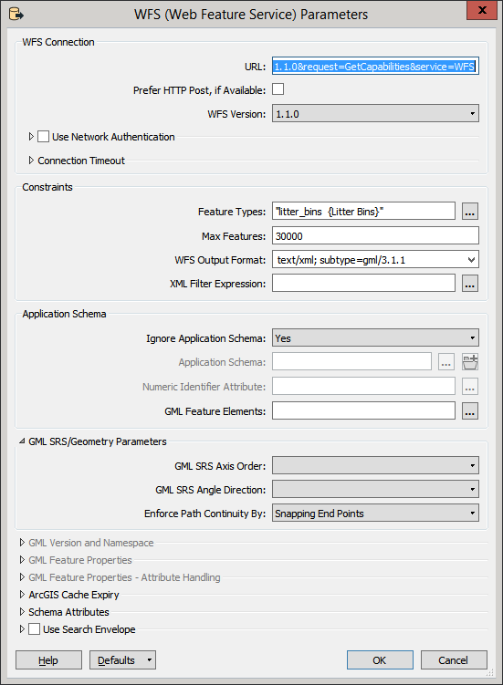
Would be grateful for some advice on this. FME is refusing to load any data from this WFS service. I can see the set of layers (get capabilities) from the service when I try to add the reader but when I select the data layer I need and hit ok the log is giving me the error below.

This WFS service loads vectors just fine into Qgis but not FME. Any help would be appreciated.

http://www2.guildford.gov.uk/ishare5.2.web/getows....

The top-level type definition referred to by the 'type' attribute in the element declaration is missing from the XML Schema

QName: 'ms:ogc_fid' | namespace uri:'http://mapserver.gis.umn.edu/mapserver'

QName: 'Integer' | namespace uri:'http://www.w3.org/2001/XMLSchema'

<element xmlns="http://www.w3.org/2001/XMLSchema" name="ogc_fid" type="Integer"/>

Best answer by geosander

Hi James,

I tried your URL in FME 2016 with these settings:

It worked for me..

The trick is to set "Ignore Application Schema" to "Yes". Might not be the proper way, but I did receive features from the WFS like that.

View original
Did this help you find an answer to your question?
This post is closed to further activity.
It may be a question with a best answer, an implemented idea, or just a post needing no comment.
If you have a follow-up or related question, please post a new question or idea.
If there is a genuine update to be made, please contact us and request that the post is reopened.

4 replies

geosander
Forum|alt.badge.img+7
  • Best Answer
  • February 26, 2016

Hi James,

I tried your URL in FME 2016 with these settings:

It worked for me..

The trick is to set "Ignore Application Schema" to "Yes". Might not be the proper way, but I did receive features from the WFS like that.


Forum|alt.badge.img+4
geosander wrote:

Hi James,

I tried your URL in FME 2016 with these settings:

It worked for me..

The trick is to set "Ignore Application Schema" to "Yes". Might not be the proper way, but I did receive features from the WFS like that.

Brilliant....works fine for me too! Thanks for taking the time to investigate.

regards

James


geosander
Forum|alt.badge.img+7
  • February 26, 2016
james_rutter wrote:

Brilliant....works fine for me too! Thanks for taking the time to investigate.

regards

James

No problem! :)


What still puzzles me is if FME has problems reading this application schema for some reason, or that QGIS just is more lenient (and ignores the application schema automatically if it fails validation, for instance).

fmelizard
Contributor
Forum|alt.badge.img+17
  • Contributor
  • February 27, 2016
geosander wrote:

No problem! :)


What still puzzles me is if FME has problems reading this application schema for some reason, or that QGIS just is more lenient (and ignores the application schema automatically if it fails validation, for instance).

I don't know firsthand but have overheard that QGIS generally ignores the application schema and hence is much more forgiving than we traditionally were. So we added the ignore option for cases like this. Glad it was helpful here.


Cookie policy

We use cookies to enhance and personalize your experience. If you accept you agree to our full cookie policy. Learn more about our cookies.

 
Cookie settings