Could someone recommend the best transformer for converting 2 point clouds to a geotiffs so that they can be compared for differences in elevations? Also what is recommended to use as a surface tolerance and output dem x and y spacings using the Rasterdemgenerator? I have two point clouds representing 2 different years. I would like to compare any differences in elevations by calculating the difference in elevations. The area is very flat and differences can be less than 1m. Any guidance appreciated. thanks

Page 1 / 1
No need to convert them to rasters, I've done this by a 2DGridAccumulator (create a grid of points) and then 2 SurfaceDrapers (one for each point cloud). Per point you can get 2 elevation readings and then the difference is a simple calculation.
The grid spacing determines how dense your result grid will be. What values you pick depend on the average (horizontal) size of elevation differences you want to pick up.
@redgeographics
Ok thanks, I was hoping there was a way to directly use the two point clouds instead of creating tiffs first. Could you explain a bit more about the workspace that you created? I have 2 separate .xyz files representing 2 different years that I want to compare. The area of coverage for one year is smaller than the other so the analysis will be restricted to only its coverage. Is the first step to read the 2 xyz files into 2 2DGridAccumulators or just one? I am also not sure about using 2 surface drapers. The product I want is a geotiff so that I can have full control over the classification of elevations using ArcGIS unless you know of a better way.. thanks again and sorry for the confusion@redgeographics
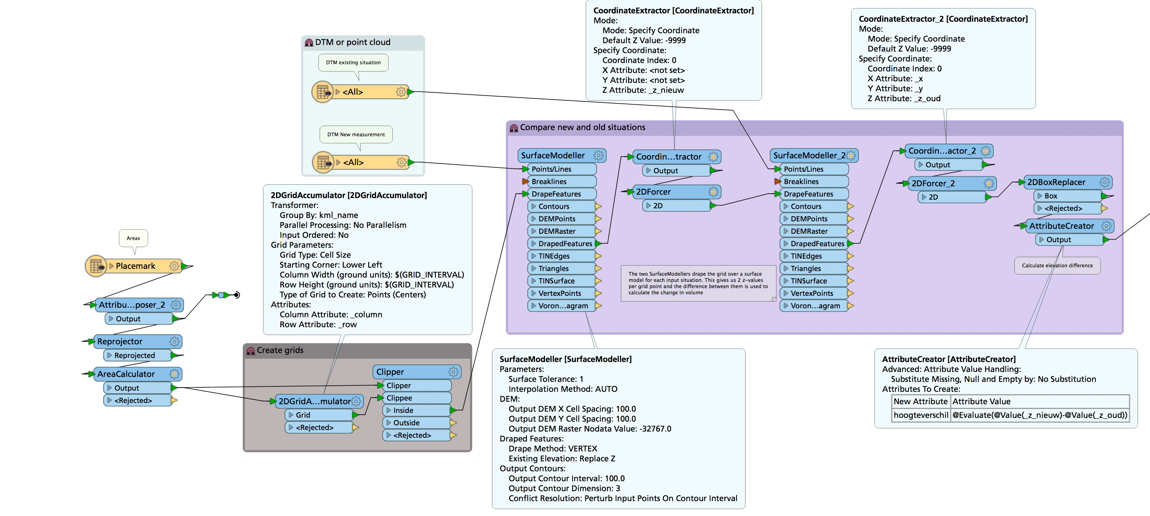
Ok thanks, I was hoping there was a way to directly use the two point clouds instead of creating tiffs first. Could you explain a bit more about the workspace that you created? I have 2 separate .xyz files representing 2 different years that I want to compare. The area of coverage for one year is smaller than the other so the analysis will be restricted to only its coverage. Is the first step to read the 2 xyz files into 2 2DGridAccumulators or just one? I am also not sure about using 2 surface drapers. The product I want is a geotiff so that I can have full control over the classification of elevations using ArcGIS unless you know of a better way.. thanks again and sorry for the confusion2 LAS/DEM/DTM inputs, "old" and "new" (anything with 3d points or lines will do really), a separate input for an area of interest which is gridded using a 2DGridAccumulator. Drape the gridpoints over a surface generated from the old terrain, grab the z coordinate in a new attribute, force them back to 2d and then repeat the process for the new terrain, grab the z coordinate in another attribute and then the elevation difference is calculated.
I presented on this at the last FMEUC: https://www.youtube.com/watch?v=W78UQ_fSfnU