I am having trouble converting shape files into MapInfo and changing the projection from UTM to Long/Lat. I have tried using FME, MapInfo Universal Translator, MapInfo Create Points. I even tried creating long/lat fields in a table and then trying to Create Points. But in all cases the files come up UTM in MapInfo not long lat even though the MapInfo default is Long/Lat.
Anyone with experience with FME and MapInfo that can help
kdmur
Best answer by david_r
Hi,
try the following:
In the Workbench, go to File / New / Generate workspace.
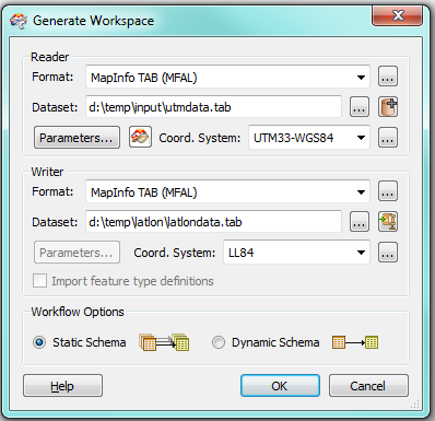
Specify the translation something like this:
What is important here:
The coordinate system has been specified for BOTH the reader and the writer (you will have to use your own values here)
The output dataset is different from the input dataset (it will be created by FME)
Did this help you find an answer to your question?
This post is closed to further activity.
It may be a question with a best answer, an implemented idea, or just a post needing no comment.
If you have a follow-up or related question, please post a new question or idea.
If there is a genuine update to be made, please contact us and request that the post is reopened.
We use 3 different kinds of cookies. You can choose which cookies you want to accept. We need basic cookies to make this site work, therefore these are the minimum you can select. Learn more about our cookies.