Question

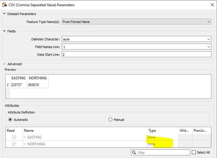
I am reading a csv file with easting and northing columns (British National Grid), however FME seems to be automatically changing them to Lat Long even though I have the projection set as EPSG:27700 or if I don't set a projection at all.


ruth_h
Contributor
Forum|alt.badge.img+4

How do I stop it changing the entries in those fields so I can create points in the correct location please?

3 replies

daveatsafe
Safer
Forum|alt.badge.img+19
  • Safer
  • April 28, 2023

Hi @ruth_h​,

Would you mind sharing a small section of that CSV file (perhaps two or three lines, plus the header)? It would be helpful to see your workspace as well.


ebygomm
Influencer
Forum|alt.badge.img+39
  • Influencer
  • May 2, 2023

Check the Attribute Definition under the csv reader parameters, i suspect they are being incorrectly interpreted as time. Change the option to manual and you can then choose the type as x-coordinate and y-coordinateimage 


ruth_h
Contributor
Forum|alt.badge.img+4
  • Author
  • Contributor
  • May 2, 2023

Thank you both for your replies. ebygomm - you are right, that's exactly it. It was annoying me so much but that fixes it. Thanks very much.


Cookie policy

We use cookies to enhance and personalize your experience. If you accept you agree to our full cookie policy. Learn more about our cookies.

 
Cookie settings