Solved

Migrating Dimensions from AutocAD to ESRI

  • 19 November 2018
  • 3 replies
  • 17 views

Badge

Hi All,

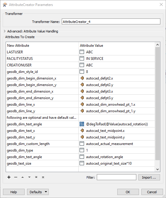
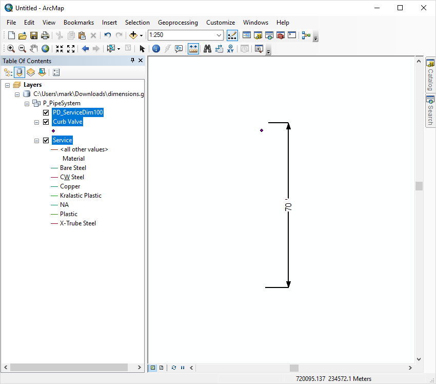
I am trying to migrate Dimensions from AutoCAD to ESRI. But while doing so, i get an error "An error occurred while attempting to set the 'DimensionShape' property on the 'IDimensionFeature' interface for the dimension feature class 'PD_ServiceDim100'. The error number from ArcObjects is: '-2147220936'. The error message from ArcObjects is: {The coordinates or measures are out of bounds.}".


I have assigned the coordinate system in dwg. I have tried by normally migrating the Dimension as well as re-projecting the same, but am getting the same error. To test, whether the coordinates are correct or not i placed a point feature in the same and was successfully able to migrate (without reprojecting) it to a point feature class in GDB. Not sure, whether any attribute is creating a problem for Dimensions. Any ideas ?

icon

Best answer by markatsafe 19 November 2018, 23:18

View original

3 replies

Badge +2

@bb Thank you for including the sample data and your workspace. This makes it much easier to help answer your question about creating dimensions in an Esri Geodatabase. You are actually quite close. The intuitive thing to do is to map the AutoCAD format attributes to the Esri feature class attributes - which is what you have done. For example: 

autocad_defpt2.x -> BEGINX

However, in FME, you cannot write to the Esri dimension attributes (the same is true when writing to annotations or relationship classes). You have to write to the FME geodb_* format attributes, and these are mapped to the Esri attributes in the writer. So instead of mapping to BEGINX you need the following:

autocad_defpt2.x -> geodb_dim_begin_dimension_x

The Esri dimension format attributes are documented in the Esri Geodatabase format documentation under the Dimensions section. Here are the mappings I came up with:

2018-11-19-14-11-35


There are a couple of other things you need to do in the workspace to make this work:

AutoCAD reader - make sure you have set the Advanced parameter:

Resolve Dimensions = No

Make sure the Geodatabase writer Feature Type for you dimensions has the correct geometry type:

Geometry: geodb_dimension

You need to ensure that there are dimension styles set-up for your dimension. FME cannot create the styles, so it's best to use a template geodatabase that has the appropriate styles defined. In the attached example, I'm using the File Geodb supplied by @bb 

The result is a dimension that in Arcmap looks like:

2018-11-19-12-59-37


I have attached a sample workspace as an FME template that includes the Geodb Template and source DWG: DIM_Acad2ESRI_2017 v01.fmwt

Badge

@bb Thank you for including the sample data and your workspace. This makes it much easier to help answer your question about creating dimensions in an Esri Geodatabase. You are actually quite close. The intuitive thing to do is to map the AutoCAD format attributes to the Esri feature class attributes - which is what you have done. For example: 

autocad_defpt2.x -> BEGINX

However, in FME, you cannot write to the Esri dimension attributes (the same is true when writing to annotations or relationship classes). You have to write to the FME geodb_* format attributes, and these are mapped to the Esri attributes in the writer. So instead of mapping to BEGINX you need the following:

autocad_defpt2.x -> geodb_dim_begin_dimension_x

The Esri dimension format attributes are documented in the Esri Geodatabase format documentation under the Dimensions section. Here are the mappings I came up with:

2018-11-19-14-11-35


There are a couple of other things you need to do in the workspace to make this work:

AutoCAD reader - make sure you have set the Advanced parameter:

Resolve Dimensions = No

Make sure the Geodatabase writer Feature Type for you dimensions has the correct geometry type:

Geometry: geodb_dimension

You need to ensure that there are dimension styles set-up for your dimension. FME cannot create the styles, so it's best to use a template geodatabase that has the appropriate styles defined. In the attached example, I'm using the File Geodb supplied by @bb 

The result is a dimension that in Arcmap looks like:

2018-11-19-12-59-37


I have attached a sample workspace as an FME template that includes the Geodb Template and source DWG: DIM_Acad2ESRI_2017 v01.fmwt

Thanks a lot @MarkAtSafe, the solution has yielded results. I did try geodb_dim* attributes initially, but did not get any success. This has worked finally.

Hello,

I have dimensions in autocad file but when i put the parameters in my transformer (i don't have arrowhead) :

In file atuocad i have this dimension : but after transformation in ArcGis i have that :


It's not ok because the dimension it's not a good place.

I change parameter but it's impossible for me to resolve the problem.

Can you help me please?

Thank you


Reply